Eggenthal
From Wikipedia, the free encyclopedia
Eggenthal | |
|---|---|
 Eggenthal, church | |
 Coat of arms | |
Location of Eggenthal
within Ostallgäu district  | |
 Location of Eggenthal | |
 Eggenthal  Eggenthal | |
| Coordinates: 47°55′N 10°31′E / 47.917°N 10.517°E | |
| Country | Germany |
| State | Bavaria |
| Admin. region | Schwaben |
| District | Ostallgäu |
| Government | |
| • Mayor (2020–26) | Karina Fischer[1] |
| Area | |
• Total | 28.04 km2 (10.83 sq mi) |
| Elevation | 713 m (2,339 ft) |
| Population (2023-12-31)[2] | |
• Total | 1,456 |
| • Density | 51.93/km2 (134.5/sq mi) |
| Time zone | UTC+01:00 (CET) |
| • Summer (DST) | UTC+02:00 (CEST) |
| Postal codes | 87653 |
| Dialling codes | 08347 |
| Vehicle registration | OAL |
| Website | www.eggenthal.de |
Eggenthal (German pronunciation: [ˈɛɡn̩taːl]) is a municipality in the district of Ostallgäu in Bavaria in Germany. It is located in the Allgäu region.
There are the Gemarkungs Bayersried and Eggenthal. There are also the villages of Romatsried and Holzstetten as well as several small hamlets. In Romatsried you will find the Burgstall Romatsried, a place that may have already been populated in the Bronze Age.
 Bayersried from east
 Eggenthal from southeast
 Kreuzweg
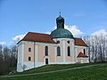 Maria-Seelenkapelle (chapel)
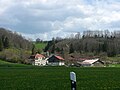 Schleifmühle
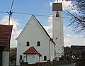 St. Afra


