Fidelis, Florida
From Wikipedia, the free encyclopedia
Fidelis, Florida | |
|---|---|
 Fidelis School | |
 Fidelis, Florida  Fidelis, Florida | |
| Coordinates: 30°56′04″N 87°01′28″W / 30.93444°N 87.02444°W | |
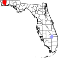
| Country | United States |
| State | Florida |
| County | Santa Rosa |
| Area | |
• Total | 2.852 sq mi (7.39 km2) |
| • Land | 2.836 sq mi (7.35 km2) |
| • Water | 0.016 sq mi (0.041 km2) |
| Elevation | 253 ft (77 m) |
| Population | |
• Total | 137 |
| • Density | 48.3/sq mi (18.7/km2) |
| Time zone | UTC-6 (Central (CST)) |
| • Summer (DST) | UTC-5 (CDT) |
| ZIP code | 32565[3] |
| Area code | 850 |
| GNIS feature ID | 2629313[2] |
Fidelis is an unincorporated community and census-designated place in Santa Rosa County, Florida, United States. Its population was 137 at the 2020 census,[4] down from 156 as of the 2010 census.[1] It is part of the Pensacola—Ferry Pass—Brent, Florida Metropolitan Statistical Area. Florida State Road 87 passes through the community.
The Fidelis School was listed on the National Register of Historic Places in 2021.[5] The building was constructed in 1925 and served as a school until the 1980s. It then served as a community center and church before being abandoned.[6]