Harold, Florida
From Wikipedia, the free encyclopedia
Harold, Florida | |
|---|---|
 The Harold Store in Harold, Florida. | |
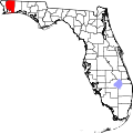
 Harold, Florida  Harold, Florida | |
| Coordinates: 30°40′25″N 86°51′20″W / 30.67361°N 86.85556°W | |
| Country | United States |
| State | Florida |
| County | Santa Rosa |
| Area | |
• Total | 14.729 sq mi (38.15 km2) |
| • Land | 14.689 sq mi (38.04 km2) |
| • Water | 0.040 sq mi (0.10 km2) |
| Elevation | 157 ft (48 m) |
| Population | |
• Total | 909 |
| • Density | 61.9/sq mi (23.9/km2) |
| Time zone | UTC-6 (Central (CST)) |
| • Summer (DST) | UTC-5 (CDT) |
| Area code | 850 |
| GNIS feature ID | 2583351[2] |
Harold is an unincorporated community and census-designated place in Santa Rosa County, in the U.S. state of Florida.[2] Its population was 909 at the 2020 census,[3] up from 823 at the 2010 census.[1] It is part of the Pensacola—Ferry Pass—Brent, Florida Metropolitan Statistical Area. A satellite field for Training Air Wing FIVE at Naval Air Station Whiting Field called OLF Harold is located here.