Finsterwalde
From Wikipedia, the free encyclopedia
Finsterwalde | |
|---|---|
 Town hall | |
 Coat of arms | |
Location of Finsterwalde
within Elbe-Elster district  | |
 Location of Finsterwalde | |
 Finsterwalde  Finsterwalde | |
| Coordinates: 51°37′42″N 13°42′37″E / 51.628243°N 13.710210°E | |
| Country | Germany |
| State | Brandenburg |
| District | Elbe-Elster |
| Subdivisions | 3 Stadtteile / 2 Ortsteile |
| Government | |
| • Mayor (2017–25) | Jörg Gampe[1] (CDU) |
| Area | |
• Total | 77.21 km2 (29.81 sq mi) |
| Elevation | 108 m (354 ft) |
| Population (2023-12-31)[2] | |
• Total | 15,864 |
| • Density | 205.5/km2 (532.2/sq mi) |
| Time zone | UTC+01:00 (CET) |
| • Summer (DST) | UTC+02:00 (CEST) |
| Postal codes | 03238 |
| Dialling codes | 03531 |
| Vehicle registration | EE, FI, LIB |
| Website | www.finsterwalde.de |
Finsterwalde (German pronunciation: [fɪnstɐˈvaldə] ⓘ, Lower Sorbian: Grabin, pronounced [ˈɡrabʲin]) is a town in the Elbe-Elster district (German: Landkreis), in Lower Lusatia, Brandenburg, Germany.
It is situated on the Schackebach, a tributary of the Kleine Elster, 28 m. W.S.W of Cottbus by rail. Pop. (2005) 18,840. The town has a Gothic church (1581), a castle, schools, cloth and cigar factories, iron-foundries, flour and saw mills and factories for machine building. Popular are the "four singers from Finsterwalde" and their "singer-song".[citation needed]
History
Finsterwalde was first mentioned in 1288. Up until the beginning of 17th century, a large part of the city's population was still speaking Lower Sorbian.[3] In 1635, Finsterwalde came into the possession of the Electorate of Saxony and from 1815 it became part of the Kingdom of Prussia.[4] From 1815 to 1947, Finsterwalde was part of the Prussian Province of Brandenburg. From 1952 to 1990, it was part of the Bezirk Cottbus of East Germany.
Demography
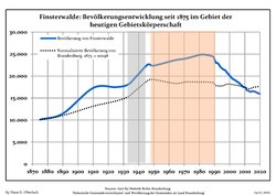 Development of population since 1875 within the current boundaries (Blue line: population; dotted line: Comparison to population development of Brandenburg state; grey background: Time of Nazi rule; red background: Time of communist rule)
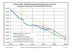 Recent Population Development and Projections: Population Development before Census 2011 (blue line); Recent Population Development according to the Census in Germany in 2011 (blue bordered line); Official projections for 2005-2030 (yellow line); for 2020-2030 (green line); for 2017-2030 (scarlet line)


Finsterwalde: Population development within the current boundaries[5] | |||||||||||||||||||||||||||||||||||||||||||||||||||||||||||||||||||||||||||||||||||||||||||||||||||||||||||||||||||||||||||||||||||||||||||||||
|
|
| |||||||||||||||||||||||||||||||||||||||||||||||||||||||||||||||||||||||||||||||||||||||||||||||||||||||||||||||||||||||||||||||||||||||||||||
Known persons

The following well known persons are from Finsterwalde:
- Hansgeorg Bätcher (1914–2003), Oberstleutnant in the Luftwaffe
- Inge Deutschkron, (1922–2022), German-Israeli journalist and author
- Thomas Eisfeld, (born 1993), football player for Arsenal FC
- Rainer Genilke (born 1968), politician
- Catrin G Grosse (born 1964), artist and painter
- Kurt Haehling (1893–1983), Generalmajor in the Wehrmacht
- Detlef Irrgang, (born 1966), football player
- Sonja Kesselschläger, Heptathlon athlete
- Hermann Kotzschmar, (1829–1908), German-American musician, conductor and composer
- Peggy Kuznik, Football player
- Otto Ostrowski, (1883–1963), Mayor of Finsterwalde in the 1920s
- Stephanie Pohl, (born 1978), beach volleyball player
- Hans-Jürgen Riediger (born 1955), football player
Buildings and Monuments
- Finsterwalde Solar Park
- Janusz-Korczak-Gymnasium, formerly Knabenschule by Max Taut (1913)
- In Finsterwalde is located a relief dedicated to Lenin in the park "Bürgerheide"[6]
Climate
| Climate data for Doberlug-Kirchhain [a] (1991–2020) | |||||||||||||
|---|---|---|---|---|---|---|---|---|---|---|---|---|---|
| Month | Jan | Feb | Mar | Apr | May | Jun | Jul | Aug | Sep | Oct | Nov | Dec | Year |
| Mean daily maximum °C (°F) | 3.4 (38.1) |
5.0 (41.0) |
9.2 (48.6) |
15.3 (59.5) |
19.7 (67.5) |
23.1 (73.6) |
25.3 (77.5) |
25.1 (77.2) |
20.1 (68.2) |
14.3 (57.7) |
8.1 (46.6) |
4.4 (39.9) |
14.4 (57.9) |
| Daily mean °C (°F) | 0.6 (33.1) |
1.5 (34.7) |
4.6 (40.3) |
9.5 (49.1) |
13.9 (57.0) |
17.3 (63.1) |
19.4 (66.9) |
19.0 (66.2) |
14.5 (58.1) |
9.6 (49.3) |
4.9 (40.8) |
1.8 (35.2) |
9.7 (49.5) |
| Mean daily minimum °C (°F) | −2.4 (27.7) |
−2.0 (28.4) |
0.3 (32.5) |
3.3 (37.9) |
7.5 (45.5) |
11.0 (51.8) |
13.2 (55.8) |
12.8 (55.0) |
9.2 (48.6) |
5.4 (41.7) |
1.7 (35.1) |
−0.9 (30.4) |
4.9 (40.8) |
| Average precipitation mm (inches) | 45.7 (1.80) |
34.0 (1.34) |
38.8 (1.53) |
27.9 (1.10) |
57.2 (2.25) |
53.4 (2.10) |
69.4 (2.73) |
61.2 (2.41) |
45.8 (1.80) |
39.4 (1.55) |
43.3 (1.70) |
44.1 (1.74) |
561.6 (22.11) |
| Average precipitation days (≥ 0.1 mm) | 17.1 | 13.7 | 15.1 | 11.0 | 13.1 | 12.9 | 14.0 | 12.7 | 11.8 | 13.8 | 15.0 | 16.4 | 166.8 |
| Average relative humidity (%) | 84.5 | 80.6 | 77.0 | 70.5 | 70.5 | 70.0 | 69.0 | 69.9 | 76.6 | 82.3 | 87.1 | 86.2 | 77.8 |
| Mean monthly sunshine hours | 55.2 | 78.0 | 124.7 | 190.8 | 224.2 | 218.7 | 228.4 | 220.4 | 163.7 | 114.1 | 62.2 | 48.3 | 1,741.3 |
| Source: NOAA[7] | |||||||||||||
