Fittstown, Oklahoma
From Wikipedia, the free encyclopedia
Fittstown, Oklahoma | |
|---|---|
 Fittstown, Oklahoma  Fittstown, Oklahoma | |
| Coordinates: 34°36′33″N 96°38′26″W / 34.60917°N 96.64056°W | |
| Country | United States |
| State | Oklahoma |
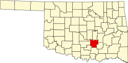
| County | Pontotoc |
| Area | |
• Total | 1.07 sq mi (2.78 km2) |
| • Land | 1.07 sq mi (2.78 km2) |
| • Water | 0 sq mi (0.00 km2) |
| Elevation | 856 ft (261 m) |
| Population (2020) | |
• Total | 78 |
| • Density | 72.8/sq mi (28.09/km2) |
| Time zone | UTC-6 (Central (CST)) |
| • Summer (DST) | UTC-5 (CDT) |
| ZIP code | 74842 |
| Area code | 580 |
| GNIS feature ID | 2805317[2] |
Fittstown is an unincorporated community in Pontotoc County, Oklahoma, United States. As of the 2020 census, Fittstown had a population of 78.[3] Fittstown is located on U.S. Route 377, 11 miles (18 km) south-southeast of Ada. Fittstown has a post office with ZIP code 74842.[4]