Latta, Oklahoma
From Wikipedia, the free encyclopedia
Latta, Oklahoma | |
|---|---|
 Latta, Oklahoma  Latta, Oklahoma | |
| Coordinates: 34°44′49″N 96°42′25″W / 34.74694°N 96.70694°W | |
| Country | United States |
| State | Oklahoma |
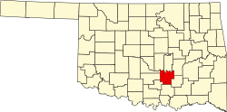
| County | Pontotoc |
| Area | |
• Total | 2.52 sq mi (6.52 km2) |
| • Land | 2.52 sq mi (6.52 km2) |
| • Water | 0 sq mi (0.00 km2) |
| Elevation | 978 ft (298 m) |
| Population (2020) | |
• Total | 1,465 |
| • Density | 581.6/sq mi (224.55/km2) |
| Time zone | UTC-6 (Central (CST)) |
| • Summer (DST) | UTC-5 (CDT) |
| Area code | 580 |
| GNIS feature ID | 2629926[2] |
Latta is an unincorporated community and census-designated place in Pontotoc County, Oklahoma, United States. As of the 2020 census, Latta had a population of 1,465.[3] Oklahoma State Highway 1 passes through the community.
According to the U.S. Census Bureau, the community has an area of 2.520 square miles (6.53 km2), all land.[4]