Gaurishankar Rural Municipality
Place in Bagmati Province, Nepal
From Wikipedia, the free encyclopedia
Gaurishankar (Nepali: ne:गौरीशंकर गाउँपालिका ), a part of Bagmati Province, Nepal, is a rural municipality located in Dolakha District. With Suri as its current official headquarters, the rural municipality consists of nine wards (previously seven Village Development Committees) covers an area of 681.39 km2 and has a population of 17,062 in 2011.[1]

Gaurishankar Rural Municipality | |
|---|---|
| गौरीशंकर गाउँपालिका | |
 Office of the Rural Municipality. | |
 Gaurishankar Rural Municipality Location in Nepal | |
| Coordinates: 27.7555116°N 86.2156601°E | |
| Country | |
| Province | Bagmati Province |
| District | Dolakha |
| Headquarters | Suri, Dolakha |
| Area | |
• Total | 681.39 km2 (263.09 sq mi) |
| Population | |
• Total | 17,062 |
| • Density | 25.040/km2 (64.853/sq mi) |
| Time zone | UTC+5:45 (Nepal Time) |
| Website | http://gaurishankarmun.gov.np/ |
It is named after Mount Gaurishankar (Nepali: ne:गौरिशंकर हिमाल), which determines Nepal time (UTC +05:45), and is also home to Tsho Rolpa Lake (also Cho Rolpa (Nepali: ne:छो-रोल्पा ताल), one of the biggest glacial lakes in Nepal.
Demographics
At the time of the 2011 Nepal census, Gaurishankar Rural Municipality]] had a population of 17,140. Of these, 60.8% spoke Nepali, 19.2% Sherpa, 13.8% Tamang, 2.7% Jirel, 1.6% Newar, 0.7% Surel, 0.3% Magar, 0.3% Thangmi, 0.2% Gurung, 0.2% Maithili and 0.1% other languages as their first language.[2]
In terms of ethnicity/caste, 35.4% were Chhetri, 20.2% Sherpa, 18.0% Tamang, 5.9% Kami, 4.4% Newar, 3.7% Jirel, 3.1% Gurung, 1.9% Damai/Dholi, 1.9% Magar, 1.7% Hill Brahmin, 1.2% Sarki, 1.0% Gharti/Bhujel, 0.8% Thami, 0.3% Thakuri, 0.1% other Terai and 0.4% others.[3]
In terms of religion, 57.3% were Hindu, 38.3% Buddhism, 2.9% Prakiriti, 1.2% Christian and 0.3% others.[4]
In terms of literacy, 56.7% could read and write, 4.7% could only read and 38.6% could neither read nor write.[5]
Political divisions

The rural municipality consists of nine wards:
- Ward No. 1 (Previously Jugu V.D.C.)
- Ward No. 2 (Previously Jugu V.D.C.)
- Ward No. 3 (Previously Jhyaku V.D.C.)
- Ward No. 4 (Previously Jhyaku V.D.C.)
- Ward No. 5 (Previously Suri V.D.C.)
- Ward No. 6 (Previously Chankhu V.D.C.)
- Ward No. 7 (Previously Marbu V.D.C.)
- Ward No. 8 (Previously Khare V.D.C.)
- Ward No. 9 (Previously Gaurishankar V.D.C.)
| Ward No. | Included VDCs | Population | Area (Sq. km.) |
|---|---|---|---|
| 1 | Jugu (1,7-9) | 1,950 | 21.8 |
| 2 | Jugu (2–6) | 1,932 | 12.05 |
| 3 | Jhyaku (5–9) | 2,395 | 16.5 |
| 4 | Jhyaku (1–4) | 2,242 | 19.41 |
| 5 | Suri (1–9) | 3,054 | 47.02 |
| 6 | Chankhu (1–9) | 1,272 | 21.78 |
| 7 | Marbu (1–9) | 1,409 | 114.02 |
| 8 | Khare (1–9) | 1,833 | 104.43 |
| 9 | Gaurishankar (1–9) | 975 | 324.38 |
| Total | 17,062 | 681.39 |
Gallery
Photo gallery of Gurumfi, Gaurishankar Rural Municipality.
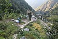 View of Gurumfi, Suri of Gaurishankar Rural Municipality, Bagmati Province, Nepal.
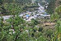 View of Gurumfi, Chankhu of Gaurishankar Rural Municipality, Bagmati Province, Nepal.

