General Tinio
Municipality in Nueva Ecija, Philippines
From Wikipedia, the free encyclopedia
General Tinio, formerly known as Papaya, is a first-class municipality in the 4th district of Nueva Ecija, Philippines.[5] According to the 2024 census, it has a population of 58,093 people.[6] It was known as Papaya until 1957, when it was renamed in honor of General Manuel Tinio through Republic Act No. 1665.[7]The municipality is located at the western foothills of the Sierra Madre Mountains, adjoining the Fort Magsaysay Army Reservation on the northeastern side.[8]

General Tinio | |
|---|---|
Welcome Arch | |
 Seal | |
 Map of Nueva Ecija with General Tinio highlighted | |
 Interactive map of General Tinio | |
.svg) General Tinio Location within the Philippines | |
| Coordinates: 15°21′N 121°03′E | |
| Country | Philippines |
| Region | Central Luzon |
| Province | Nueva Ecija |
| District | 4th district |
| Founded | 1921 |
| Named after | Manuel Tinio |
| Barangays | 13 (see Barangays) |
| Government | |
| • Type | Sangguniang Bayan |
| • Mayor | Sherry Ann D. Bolisay |
| • Vice Mayor | Melvin S. Pascual |
| • Representative | Emerson D. Pascual |
| • Municipal Council | Members |
| • Electorate | 43,627 voters (2025) |
| Area | |
• Total | 245.29 km2 (94.71 sq mi) |
| Elevation | 56 m (184 ft) |
| Highest elevation | 113 m (371 ft) |
| Lowest elevation | 32 m (105 ft) |
| Population (2024 census)[3] | |
• Total | 58,093 |
| • Density | 236.83/km2 (613.40/sq mi) |
| • Households | 13,137 |
| Economy | |
| • Income class | 1st municipal income class |
| • Poverty incidence | 12.61 |
| • Revenue | ₱ 368.1 million (2022) |
| • Assets | ₱ 627.9 million (2022) |
| • Expenditure | ₱ 299.4 million (2022) |
| • Liabilities | ₱ 329.4 million (2022) |
| Service provider | |
| • Electricity | Nueva Ecija 2 Area 2 Electric Cooperative (NEECO 2 A2) |
| Time zone | UTC+8 (PST) |
| ZIP code | 3104 |
| PSGC | |
| IDD : area code | +63 (0)44 |
| Native languages | Southern Alta Tagalog Ilocano |
| Website | www |
History
Early references and Spanish period

Papaya is first documented in the mid-19th century in the Diccionario Geográfico, Estadístico, Histórico de las Islas Filipinas (Vol. 2, 1851) by Manuel Buzeta and Felipe Bravo, where it is described as a visita (chapel-community) of the town of Gapan in the then province of Pampanga.[10] This classification indicates that Papaya was already a settled community with its own population and economic activity during the Spanish colonial period, although it remained administratively and ecclesiastically dependent on Gapan.[11] Ecclesiastical supervision was exercised through the parish centered in Gapan, now known as the Minor Basilica and National Shrine of La Virgen Divina Pastora (Three Kings Parish), one of the earliest church institutions in the province.[12]
Precolonial and early inhabitants
Prior to Spanish documentation, the area that would become Papaya was already inhabited by indigenous groups. Mid-20th century historical accounts describe the presence of Dumagat (Aeta-related) populations in the forested and upland areas surrounding the settlement, coexisting with lowland communities along river systems such as the Rio Chico.[13] These groups formed part of the earliest known inhabitants of the region and contributed to its early socio-cultural landscape.
Archaeological evidence further supports early human activity in the area. The Arubo 1 site in present-day General Tinio has yielded stone tools, including proto-handaxes and Levallois-like flakes, suggesting habitation dating back to the Lower or Middle Paleolithic period.[14] This evidence situates the area within a broader pattern of early human occupation in Central Luzon.
Administrative development
Papaya was originally part of Barrio Mapisong under the jurisdiction of Gapan.[15] In 1851, Mapisong was established as a separate pueblo and renamed Peñaranda in honor of Spanish engineer José María Peñaranda.[16] Papaya was subsequently transferred to the jurisdiction of Peñaranda and remained one of its component barrios during the late Spanish and early American periods.[17]
During the American colonial period, Papaya developed formal governance structures, including barrio officials and civic institutions. Historical records document the presence of local leaders drawn from resident families who participated in administration and community organization.[18] Among those recorded is Mamerto Padolina, listed among individuals involved in the civic and administrative life of the barrio.[19]
The same records also document the expansion of public institutions such as schools and community organizations, reflecting the gradual institutionalization of governance in the area.[20]
Transition to municipality
Papaya was constituted as an independent municipality effective January 1, 1921, through Executive Order No. 30 issued by Governor-General Francis Burton Harrison.[21] The municipality was formed from the barrios of Papaya, Pias, and Rio Chico, with Papaya designated as the poblacion.[22]
Territorial reorganization and the creation of Palayan
In the mid-20th century, the provincial government of Nueva Ecija initiated plans to transfer the provincial capital from Cabanatuan to a newly established administrative center.[23] Following consultations in 1952, a site within government-owned lands, including portions of a state-operated stock farm, was selected for development.[24] This led to the enactment of Republic Act No. 4475 on June 19, 1965, which created the City of Palayan as the new provincial capital.[25]
The establishment of Fort Magsaysay in 1955 and the creation of Palayan City resulted in adjustments to the territorial boundaries of surrounding municipalities, including General Tinio, Laur, and Santa Rosa.[26] Contemporary local accounts indicate that certain peripheral areas, including communities such as Palale, were affected by these administrative realignments, with some areas later reaffirmed under the jurisdiction of General Tinio.[27]
Renaming to General Tinio
In 1957, the municipality of Papaya was renamed General Tinio through Republic Act No. 1665, in honor of General Manuel Tinio, a revolutionary leader from Nueva Ecija.[28] The measure was sponsored in Congress by Representative Celestino Juan and approved on June 20, 1957.[29]
The renaming occurred within a broader context of postwar institutional development and local governance. Historical accounts document the participation of municipal officials and community leaders during this period, including individuals from established families such as Bienvenido Abes, who were active in civic and administrative affairs.[30]
These local figures formed part of the broader civic leadership that accompanied the municipality’s transition and institutional consolidation in the years surrounding its renaming.[19]
Geography
Location and boundaries
General Tinio is a landlocked municipality in the province of Nueva Ecija, located in the eastern portion of Central Luzon. It lies along the transitional zone between the Central Luzon Basin and the western foothills of the Sierra Madre mountain range.[31]
It is bounded by Peñaranda, Nueva Ecija to the west, San Leonardo, Nueva Ecija to the northwest, Fort Magsaysay in Palayan, Nueva Ecija to the north, Gapan to the south, and Dingalan of Aurora province to the east across the Sierra Madre range.[32]
The municipality’s location reflects settlement patterns consistent with Spanish colonial planning principles under the Leyes de Indias, where towns were established near river systems to support agriculture, transport, and administration.
Topography and landforms
General Tinio occupies a geomorphological transition zone between lowland alluvial plains and upland mountainous terrain associated with the Sierra Madre.[31]
The western portion consists of generally level to rolling plains formed by fluvial deposition, while the eastern portion rises into hilly and mountainous terrain. Elevation ranges from approximately 30 meters above sea level in lowland areas to over 1,200 meters in upland barangays such as Pias.[33]
The variation in terrain influences land use patterns across the municipality. The lowland plains, formed by fertile alluvial deposits, are predominantly used for irrigated agriculture, particularly rice cultivation and other crops typical of Central Luzon. In contrast, the upland and sloping areas toward the Sierra Madre are used for eco-tourism[34] and to more suited diversified land use, including agroforestry systems that combine trees with crops to improve soil stability and reduce erosion.[35][36]
Such upland environments are commonly associated with mixed vegetation cover and tree-based farming systems in the Philippines, reflecting both ecological constraints and adaptation to terrain.[37]
A defining landform is the karst landscape of Minalungao National Park, established as a protected area under Republic Act No. 5100 (1967).[38]
The park is characterized by:
- Limestone cliffs rising up to 16 meters along the Peñaranda River
- Karst features such as caves, fissures, sinkholes, and aquifers
- Secondary-growth forest ecosystems
Recent ecological studies describe Minalungao as a karst forest system covering approximately 2,000 hectares of limestone terrain.[39]
Hydrography
General Tinio is traversed by four principal river systems identified in archaeological and environmental studies:
- Peñaranda River – a major river system in Nueva Ecija
- Rio Chico River – a tributary within the Pampanga River basin
- Sumacbao River – the largest tributary of the Peñaranda River
- Tabuating River – a northern tributary linked to irrigation systems
These rivers are documented in archaeological surveys of the Arubo site and form part of the broader Pampanga River watershed.[40]
River systems in the municipality originate partly from upland forest areas and sustain irrigation networks such as the Upper Tabuating Irrigation Project.[41]
Geology
Regional geological setting
General Tinio lies at the interface of the Central Luzon Basin and the Sierra Madre mountain system. Its geology consists primarily of:
- Neogene sedimentary formations (sandstone, siltstone, claystone)
- Alluvial deposits from river systems
- Limestone and karst formations
Tectonic uplift associated with the Philippine Fault system and Sierra Madre orogeny, combined with fluvial processes, has shaped the municipality’s present landscape.[42]

Karst and limestone formations
The limestone formations of Minalungao represent a classic tropical karst environment formed through prolonged dissolution of carbonate rocks. These formations include:
- Steep limestone cliffs
- Subsurface drainage systems (aquifers)
- Sinkholes and caves
Soils associated with these formations include Annam loam (gravelly phase) and Sibul clay, both of which are documented in DENR protected area profiles.[33]
Karst soils are typically rich in calcium and magnesium, influencing vegetation and agricultural potential.[43]
Lithic resources and archaeology
The Arubo archaeological site in Barangay Rio Chico is a significant geological and cultural locality. Excavations revealed:
- Chert outcrops and boulders
- Stone tool assemblages (cores, flakes, proto-handaxes)
- Levallois-like flaking techniques
These chert deposits are interpreted as silicified residues from limestone and represent the only documented primary chert source used for stone tool production in the Philippines.[31]
The site has been linked to the Lower Palaeolithic record of the Philippines and demonstrates early human exploitation of geological resources.[31]
Stratigraphy and soils
Stratigraphic observations at Arubo indicate:
- Sandstone bedrock layers
- Overlying clay-rich sediments with iron oxide and calcite concentrations
Lowland areas contain fertile alluvial soils suitable for rice cultivation, while upland karst zones produce mineral-rich soils that support distinct vegetation communities.[44]
Soil pH studies in Nueva Ecija indicate generally acidic to neutral soils across the province.[45]
Geomorphic processes
The landscape of General Tinio continues to be shaped by:
- River incision from the Peñaranda, Rio Chico, Sumacbao, and Tabuating rivers
- Tectonic uplift associated with the Sierra Madre
These processes expose bedrock, transport sediments, and create fertile alluvial plains alongside karst gorges.[31]
Geological significance
General Tinio’s geology integrates three major systems:
- Alluvial and fluvial deposits supporting agriculture
- Karst limestone systems supporting biodiversity
- Lithic resources linked to prehistoric tool-making
This combination has sustained human-environment interaction from the Palaeolithic period to the present.[31]
Archaeology
The municipality of General Tinio, Nueva Ecija contains one of the most significant Paleolithic open-air sites in Central Luzon, known as the Archaeological Site (General Tinio), located in Barangay Rio Chico near the Peñaranda River. Archaeological investigations conducted in 2001 by the University of the Philippines Archaeological Studies Program in collaboration with the National Museum of the Philippines identified the area as a lithic scatter associated with early human activity.[46][47]
The site lies within a gently undulating fluvial landscape with access to water and raw material sources, particularly chert, a stone suitable for tool production. The presence of large chert boulders suggests that the area functioned as a local source of raw material and possibly a production site for stone tools.[48]
Excavations, including controlled test pits, revealed stratified deposits containing lithic artefacts such as flakes, cores, and pebble tools. Some specimens exhibit characteristics comparable to the Levallois-like method, indicating a level of planning and technological sophistication in stone tool production.[49]
A notable discovery is a proto-handaxe, a bifacial tool associated with early Acheulean-like technology, a stone tool tradition generally dated from approximately 1.76 million to around 200,000 years ago during the Lower Paleolithic period.[50]
Such finds are rare in Southeast Asia and are often discussed in relation to the Movius Line, a theoretical boundary proposed by Hallam L. Movius describing the distribution of early stone tool traditions.[51][52]
The Arubo findings contribute to ongoing discussions on early human dispersal and technological variability in Island Southeast Asia, suggesting that prehistoric populations in the Philippines may have exhibited more complex lithic traditions than previously assumed.[53]
Climate
General Tinio has a tropical monsoon climate (Type I under the Corona classification), characterized by:
- A wet season from May to November
- A dry season from December to April
Climate data from nearby stations indicate average temperatures ranging from 20 °C to 34 °C and annual rainfall of approximately 661 mm.[54]
| Climate data for General Tinio, Nueva Ecija | |||||||||||||
|---|---|---|---|---|---|---|---|---|---|---|---|---|---|
| Month | Jan | Feb | Mar | Apr | May | Jun | Jul | Aug | Sep | Oct | Nov | Dec | Year |
| Mean daily maximum °C (°F) | 29 (84) |
30 (86) |
31 (88) |
34 (93) |
33 (91) |
31 (88) |
30 (86) |
29 (84) |
29 (84) |
30 (86) |
30 (86) |
29 (84) |
30 (87) |
| Mean daily minimum °C (°F) | 20 (68) |
20 (68) |
20 (68) |
22 (72) |
24 (75) |
24 (75) |
24 (75) |
24 (75) |
24 (75) |
23 (73) |
22 (72) |
21 (70) |
22 (72) |
| Average precipitation mm (inches) | 4 (0.2) |
4 (0.2) |
5 (0.2) |
11 (0.4) |
66 (2.6) |
99 (3.9) |
127 (5.0) |
113 (4.4) |
99 (3.9) |
84 (3.3) |
35 (1.4) |
14 (0.6) |
661 (26.1) |
| Average rainy days | 2.2 | 1.9 | 3.2 | 5.3 | 16.1 | 20.8 | 23.5 | 22.8 | 22.2 | 16.5 | 8.9 | 3.5 | 146.9 |
| Source: Meteoblue[55] | |||||||||||||
Demographics
Population census of General Tinio | |||||||||||||||||||||||||||||||||||||||||||||||||
|
| ||||||||||||||||||||||||||||||||||||||||||||||||
| Source: Philippine Statistics Authority[56][57][58][59] | |||||||||||||||||||||||||||||||||||||||||||||||||
Economy
Poverty incidence of General Tinio
35.19
12.48
19.70
15.69
15.38
14.92
5.10
12.61
Source: Philippine Statistics Authority[60][61][62][63][64][65][66][67]
Farming is the livelihood of the majority of the residents. Even though the municipality is located at the foot of the Sierra Madre Mountain Range, the topography is generally ideal for agricultural products such as palay and vegetables. A number of poultry broiler contract growers are also located in the municipality. Other industries include furniture and fixtures, backyard poultry, cattle and livestock, vegetable production, and minor agricultural livelihoods such as duck raising.[citation needed]
The remittances of numerous sons and daughters of Papaya abroad also help keep the economy of the town afloat. Papayanos can be relied to answer calls of assistance for the town's development.
Minalungao National Park is also one of the biggest attractions in the town, catering to numerous visitors each day.
Government
Local Municipal Government
The following have led the town from its birth in 1921 to what it had become today.[68]
| Cristobal Mangulabnan | Vice Martin Ramos | 1921–1922 |
| Getulio Bote, Sr. | Vice Martin Pajarillaga | 1922–1925 |
| Martin Pajarillaga | Vice Marcos Bote Sr. | 1925–1931 |
| Marcos Bote Sr. | Vice Daniel Padolina | 1931–1934 |
| Melquiades Ronquillo, Sr. | Vice Santiago Bolisay | 1934–1937 |
| Mayor | Vice Mayor | Term |
|---|---|---|
| Damaso Bolisay | 1937–1940 | |
| Getulio Bote | Vice Pedro Bulacan | 1940–1944 |
| Getulio Bote | Vice Angeles Bote | 1945 |
| Republic Era | ||
| Gerardo Rivera | Vice Angeles Bote | 1946–1947 |
| Gerardo Rivera | Vice Diosdado Bote | 1948–1951 |
| Gerardo Rivera with | Victorino Bote | 1952–1955 |
| Bienvenido B. Abes | Vice Victorino Bote | 1956–1959 |
| Gerardo Rivera | Vice Banaag Leodones | 1960–1963 |
| Santos Bote | Vice Getulio Bote, Jr. | 1964–1967 |
| Mariano Ronquillo | Vice Manuel Domingo | January 1–15, 1968 |
| Manuel Domingo | Vice Perfecto M. Bote | 1968–1971 |
| Nicanor B. Aves | Vice Alfonso Pajimna | 1972–1980 |
| Nathaniel Bote, Jr. | Vice Venancio Bote | 1981–1986 |
| OIC Gerardo Rivera | Vice Antonio Abes | 1986–1988 |
| Placido M. Calma | Vice Bernardino R. Abes | 1988–1995 |
| Placido M. Calma | Vice Elsa Bote | 1995–1998 |
| Placido M. Calma | Vice Bernardino R. Abes | 1998–2004 |
| Isidro Tinio Pajarillaga | Vice Indira P. Dayupay | 2004–2007 |
| Virgilio A. Bote | Vice Marcelo B. Abes | 2007–2010 |
| Virgilio A. Bote | Vice Engr. Ferdinand P. Bote | 2010–2016 |
| Engr. Ferdinand P. Bote | Vice Atty. Melvin S. Pascual | 2016–2018 |
| Atty. Melvin S. Pascual | Vice Anna Rouselle Busalpa | 2018-2019 |
| Isidro Tinio Pajarillaga | Vice Atty. Melvin S. Pascual | 2019–2025 |
| Sherry Ann Bolisay | Vice Atty. Melvin S. Pascual | 2025–present |
Sangguniang Barangay (Barangay Council)
General Tinio is politically subdivided into 13 barangays. Each barangay consists of puroks and some have sitios.[41]
- Padolina (Barangay 1)
- Concepcion (Barangay 2)
- Rio Chico (Barangay 3)
- Pias (Barangay 4)
- Nazareth (Barangay 5)
- Bago (Barangay 6)
- Poblacion West (Barangay 7)
- Poblacion Central (Barangay 8)
- San Pedro (Barangay 9)
- Sampaguita (Barangay 10)
- Poblacion East (Barangay 11)
- Pulong Matong (Barangay 12)
- Palale (Barangay 13)
Historical Development
General Tinio is politically subdivided into 13 barangays. These administrative units evolved from earlier barrios and sitios that formed part of Peñaranda, Nueva Ecija prior to the creation of the municipality of Papaya (now General Tinio) in 1921.[69]
The present barangay system was formalized during the martial law period through Presidential Decree No. 86 (1972), which created Citizens Assemblies in each barrio, and Presidential Decree No. 557 (1974), which officially renamed all barrios as barangays and adopted the Revised Barrio Charter as the Barangay Charter.[70][71]
The barangays developed from three principal early settlements: Papaya (town proper), Pias, and Rio Chico. These were formerly barrios under Peñaranda and became the core of the municipality when Papaya was established as an independent town in 1921.[69]
- Rio Chico (3) – One of the earliest settlements in the municipality, historically identified as a riverine community situated along a local water system. Early historical accounts preserved through the NHCP Memory Project record that the area was formerly known by its vernacular name Ilog na Munti, later rendered in Spanish as Rio Chico.[72] The same records list several sitios under its jurisdiction, including Arubo, Pantay, Bulak, Binumbunan, Bical-bical, and Sibug, reflecting its role as a source settlement from which surrounding communities developed.[73][74]
- Pias (4) – Described in the NHCP-preserved historical papers as a barrio of Papaya that had formerly been a sitio of Rio Chico. The document records several sitios associated with Pias, including Sapangbato, Bako or Bacog, Maipit, Talbak, Sapang-gogo, Kaputatan, and Sabia.[75] Historical data papers preserved through the NHCP Memory Project describe Pias as formerly a sitio of Rio Chico.
- Padolina – One of the principal pre-1975 barrios of the municipality, Padolina forms part of the early administrative core of General Tinio together with Rio Chico, Pias, Concepcion, Bago, and Nazareth.[76] These barrios developed from earlier sitios that were formerly under the jurisdiction of Peñaranda, Nueva Ecija prior to the creation of the municipality of Papaya in 1921.[77] Historical data papers preserved through the NHCP Memory Project document the emergence of organized barrio governance in Papaya during the American colonial period, with local officials and civic leaders drawn from resident families participating in administration and community development.[78] Within this context, the name “Padolina” is associated with Mamerto Padolina, who is listed among individuals involved in the civic and administrative life of the community during its formative years.[79]
- Concepcion (2) – One of the earlier organized barrios of the municipality, its name reflects Spanish-era Catholic naming conventions associated with Marian devotion. The title “Concepcion” refers to the Immaculate Conception of the Blessed Virgin Mary, a devotion widely promoted in the Philippines during the Spanish colonial period, particularly by religious orders such as the Franciscans, who played a significant role in spreading Marian veneration across Central Luzon.[80] The presence of the Church of the Immaculate Conception within the barangay reinforces this religious and historical association.[81]
- Nazareth – One of the early barrios of General Tinio, Nazareth was formerly known as Querollo, as recorded in mid-20th century historical data papers preserved through the NHCP Memory Project.[82] The same records describe Querollo as a former sitio of Rio Chico that developed into a distinct barrio in the early part of the 20th century, reflecting the pattern of settlement expansion from riverine communities toward inland areas. The adoption of the name “Nazareth” reflects Spanish-era Catholic naming conventions, consistent with the broader pattern observed in Nueva Ecija, where barrios were often named after Biblical or religious references following the establishment of more permanent settlements and ecclesiastical influence.[83]
- Bago (6) – identified as one of the barrios of General Tinio prior to the barangay reorganization of the 1970s, Bago forms part of the early administrative core of the municipality together with Rio Chico, Pias, Concepcion, Padolina, and Nazareth.[84] Local historical data papers preserved through the NHCP Memory Project associate the origins of the barangay with the former sitio of Baste, one of the smaller settlements that developed during the late Spanish and early American periods.[85] Within these accounts, Teniente Celino Bago is recorded as the first and last local leader of the sitio, reflecting the transitional nature of early barrio governance structures during this period.[86]
- Following national reforms under Presidential Decree No. 86 (1972) and Presidential Decree No. 557 (1974), the original Poblacion area was subdivided into six barangays: Poblacion Central, Poblacion East, Poblacion West, Pulong Matong, Sampaguita, and San Pedro.[87]
- San Pedro – Follows the common Philippine practice of saint-based naming, reflecting Catholic influence in local toponymy.[88] The barangay is locally associated with Maestro Pedro “Bigas” Bautista (1905–1973), a bandleader and music teacher recognized in community markers as the “Ama ng Musika” of General Tinio.[89] A commemorative marker installed through local legislation—authorized by Sangguniang Bayan Resolution Blg. 062 (December 2002) and initiated by the Sangguniang Barangay of San Pedro—recognizes Bautista’s role in training local youth and contributing to the development of the municipality’s brass band tradition, which has been described locally as a defining cultural identity of General Tinio.[90]
- Pulong Matong (12) – Believed to derive from its geographic setting, surrounded by river systems including the Peñaranda River and smaller tributaries such as Bical-bical, consistent with early settlement patterns along waterways.[91][92]
- Palale (13) – Formerly a sitio of Nazareth; later transferred to Palayan City as part of the creation of a new provincial capital - Republic Act 4475. General Tinio’s jurisdiction in 2006.[93] It was established in 1982 previously a sitio of Barangay Nazareth and part of Palayan City. However, in 1999, under the leadership of Mayor Virgilio Abes Bote, the Local Government of General Tinio filed a territorial dispute to reclaim Palale from the City of Palayan and on September 7, 2006 by virtue of the Decision of Supreme Court First Division in G.R. No. 169089, According to the municipal government, Palale was formerly a sitio of Barangay Nazareth, became part of Palayan City in 1982, and was later declared part of General Tinio’s territorial jurisdiction by the Supreme Court First Division in G.R. No. 169089 on September 7, 2006.[94]
Settlement pattern
The evolution of barangays in General Tinio reflects a layered historical pattern:
- River-based and agrarian settlements (Rio Chico, Pias)
- Centralized poblacion development (Papaya)
- Expansion into sitios and peripheral communities
- Formalization under barangay reforms (1972–1974)
Education
The Gen. Tinio Schools District Office governs all educational institutions within the municipality. It oversees the management and operations of all private and public educational institutions ranging from primary to secondary schools.[95]
Primary and elementary schools
- Bago Elementary School
- BC Achievers' Integrated School
- Bethany Ecumenical School
- Bulak Primary School
- Christian Lights Academy
- Gawad Kalinga Community Elementary School
- Gen. Tinio Central School
- Gen. Tinio East Central School
- Gen. Tinio West Central School
- Gethsemane Christian School
- Greenland Elementary School
- IEMELIF Learning Center
- Mapedya Elementary School
- Minalungao Elementary School
- Nazareth Elementary School
- Padolina Elementary School
- Palale Elementary School
- Patindig-Araw Elementary School
- Pias Elementary School
- Rio Chico Elementary School
- Sibug Elementary School
Secondary schools
- General Tinio National High School
- Irenea Integrated School
- Leonor M. Bautista High School
- Lino P. Bernardo National High School
- Pagtalunan High School
- Palale High School
- Rio Chico National High School
Higher educational institution
- St. Anthony Center of Science and Technology
- Nueva Ecija University of Science and Technology (NEUST) General Tinio Papaya Off NEUST- GTP
Culture
Religion
Roman Catholicism is the predominant religion in the municipality, with other Christian denominations such as Iglesia ni Cristo, IEMELIF, Baptist, and Methodist maintaining active congregations. The town’s patron saint, the San Isidro Labrador, is honored annually in May through religious rites and community festivities.[96]
The veneration of San Isidro Labrador is widespread across Nueva Ecija, reflecting the province’s agricultural identity and historical traditions. This devotion is closely associated with the former provincial capital, San Isidro, Nueva Ecija, where the saint has long been a central figure in religious and agrarian celebrations. The continued observance of San Isidro in General Tinio and neighboring towns illustrates the persistence of shared provincial traditions rooted in farming culture and colonial-era Catholic practices.[97]
Fiesta
Foundation Day Festival
The municipality also celebrates a local festival commonly referred to as the Papaya Festival or Biyaya Festival (2026), coinciding with its foundation anniversary. The event typically features parades, performances, and community participation, with costumes and themes inspired by the local-favorite freshwater fish - biya- and the papaya fruit, from which the town derived its original name before its renaming in 1957.[98]
Pistang Kalamay
At the barangay level, local festivals preserve agrarian, riverine, and food traditions. In Barangay Rio Chico, the Pistang Kalamay is celebrated during the last week of August, highlighting rice-based food heritage associated with agricultural and river-based livelihoods. Recent activities have included communal preparation of kalamay and local cook-offs intended to promote the town’s culinary heritage.[99]
Araquio Festival
One of the municipality’s enduring religious folk traditions is the presentation of the Arakyo in Barangay Pias during its annual fiesta. The Arakyo is a traditional Tagalog religious folk drama combining music, dance, dialogue, and procession, often depicting themes associated with the search for the Holy Cross. Its continued performance in the town, especially in Barangay Pias, reflects a shared cultural tradition with neighboring Peñaranda, Nueva Ecija, where the Araquio is also a registered intangible heritage[100]. This continuity is rooted in historical ties, as the areas that now comprise General Tinio were formerly under the jurisdiction of Peñaranda before Papaya became a separate municipality in 1921.[101][102]
Music
General Tinio is also known for its brass band tradition, with local accounts describing the municipality as having one of the highest concentrations of organized brass bands in the Philippines. This musical culture may be understood within the wider Gapan–Peñaranda–Papaya historical corridor, where Spanish-era religious and civic life encouraged the use of bands in fiestas, processions, and public ceremonies.[103][104]
The tradition is reflected in the life of National Artist for Music Felipe Padilla de León, who was born in Sitio Papaya, then part of Peñaranda and now part of General Tinio. De León was trained in the local band environment, having played horn in the Banda Pagkakaisa of Peñaranda during his youth, before becoming one of the country’s leading composers and later president of the Pambansang Samahan ng mga Banda sa Pilipinas (PASAMBAP).[105][106]
Within the municipality, brass bands remain central to civic, religious, and social life. They perform in fiestas, parades, competitions, and commemorative events, and are also commonly engaged during wakes, where musicians play for several hours, often performing the favorite songs of the deceased or selections requested by the bereaved family. Bands also accompany funeral processions from the residence or chapel to the church and onward to the cemetery, making music part of communal mourning and remembrance. Local groups such as the Family Band have also won national brass band competition titles in categories including majorette exhibitions and solo performances for flute, clarinet, trumpet, and French horn.[107][108]
Recreation and Leisure
The municipality’s cultural life is also closely tied to its river systems, which originate from the foothills of the Sierra Madre and flow toward neighboring lowland towns. These rivers and smaller tributaries historically shaped settlement, agriculture, and recreation. Minalungao National Park, known for its limestone formations, caves, and river gorge, is the best-known tourist destination among these waterways. For local residents, however, Minalungao is part of a wider landscape of rivers, streams, rivulets, and small falls where swimming, picnics, and riverside gatherings remain common, particularly during the dry season and Holy Week.[109][110]
Renowned Personalities
Felipe Padilla De Leon, Composer and Conductor[111]. Conferred to the Order of National Artists of the Philippines[112]. Founder of Filipino Society of Composers, Authors and Publishers, Inc. (FILSCAP) [113], Founder of Pambansang Samahan ng mga Banda sa Pinas, Inc. (National Band Organization of the Philippines, Inc.) [114]
Gallery
 Town hall
 Sports center
 Old Santo Cristo Parish Church
 New Holy Cross Parish Church
 Public market
 Cory Aquino memorial
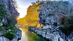
 The Upper Tabuating Dam at Brgy. Nazareth


