Gerbstedt
From Wikipedia, the free encyclopedia
Gerbstedt | |
|---|---|
 Coat of arms | |
Location of Gerbstedt within Mansfeld-Südharz district 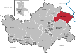 | |
 Gerbstedt  Gerbstedt | |
| Coordinates: 51°38′N 11°37′E / 51.633°N 11.617°E | |
| Country | Germany |
| State | Saxony-Anhalt |
| District | Mansfeld-Südharz |
| Subdivisions | 9 |
| Government | |
| • Mayor (2021–28) | Ulf Döring[1] (CDU) |
| Area | |
• Total | 102.31 km2 (39.50 sq mi) |
| Elevation | 155 m (509 ft) |
| Population (2022-12-31)[2] | |
• Total | 6,790 |
| • Density | 66/km2 (170/sq mi) |
| Time zone | UTC+01:00 (CET) |
| • Summer (DST) | UTC+02:00 (CEST) |
| Postal codes | 06347 |
| Dialling codes | 03476, 034773, 034783 |
| Vehicle registration | MSH, EIL, HET, ML, SGH |
Gerbstedt (German pronunciation: [ˈɡɛʁpˌʃtɛt] ⓘ) is a small town in Saxony-Anhalt, district Mansfeld-Südharz. It was traditionally dominated by copper mining, presently agriculture is dominant.
 Tower of former monastery Gerbstedt
 Town hall Gerbstedt
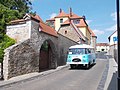 View of Gerbstedt with a rare Robur bus


Divisions
The town Gerbstedt is located 9 km (5.59 mi) west of Hettstedt and 13 km (8.08 mi) north of the town Eisleben.
The town of Gerbstedt is divided into twelve localities (Ortschaften),[3] corresponding to the twelve former municipalities that formed the current town in 2010.[4] Some of the localities consist of a number of Ortsteile (local parts).
- Augsdorf
- Freist (incl. Elben, Oeste, Reidewitz, Zabitz)
- Friedeburg
- Friedeburgerhütte (incl. Adendorf)
- Gerbstedt
- Heiligenthal (incl. Helmsdorf, Lochwitz)
- Hübitz
- Ihlewitz (incl. Pfeiffhausen, Straußhof, Thaldorf)
- Rottelsdorf (incl. Bösenburg)
- Siersleben (incl. Thondorf)
- Welfesholz
- Zabenstedt

