Seegebiet Mansfelder Land
From Wikipedia, the free encyclopedia
Seegebiet Mansfelder Land | |
|---|---|
Location of Seegebiet Mansfelder Land within Mansfeld-Südharz district 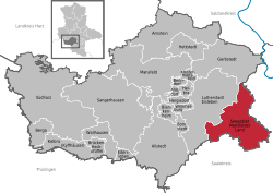 | |
 Seegebiet Mansfelder Land  Seegebiet Mansfelder Land | |
| Coordinates: 51°28′N 11°41′E / 51.467°N 11.683°E | |
| Country | Germany |
| State | Saxony-Anhalt |
| District | Mansfeld-Südharz |
| Government | |
| • Mayor (2023–30) | Martin Blümel[1] |
| Area | |
• Total | 107.92 km2 (41.67 sq mi) |
| Elevation | 95 m (312 ft) |
| Population (2022-12-31)[2] | |
• Total | 8,812 |
| • Density | 82/km2 (210/sq mi) |
| Time zone | UTC+01:00 (CET) |
| • Summer (DST) | UTC+02:00 (CEST) |
| Postal codes | 06317, 06295 |
| Dialling codes | 034776, 034774, 034601 (Amsdorf, Wansleben am See), 034773 (Dederstedt, Neehausen), 03475 (Lüttchendorf, Neehausen) |
| Vehicle registration | MSH, EIL, HET, ML, SGH |

Seegebiet Mansfelder Land is a municipality in the Mansfeld-Südharz district, Saxony-Anhalt, Germany. It was formed on 1 January 2010 by the merger of the former municipalities Amsdorf, Aseleben, Erdeborn, Hornburg, Lüttchendorf, Neehausen, Röblingen am See, Seeburg, Stedten and Wansleben am See. On 1 September 2010 Dederstedt was absorbed into the municipality.[3] These 11 former municipalities are now Ortschaften or municipal divisions of Seegebiet Mansfelder Land.[4]
