Grayhawk, Missouri
From Wikipedia, the free encyclopedia
Grayhawk, Missouri | |
|---|---|
 Grayhawk, Missouri  Grayhawk, Missouri | |
| Coordinates: 37°55′52″N 90°14′20″W / 37.93111°N 90.23889°W | |
| Country | United States |
| State | Missouri |
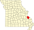
| County | Ste. Genevieve |
| Area | |
• Total | 4.70 sq mi (12.18 km2) |
| • Land | 4.35 sq mi (11.27 km2) |
| • Water | 0.35 sq mi (0.90 km2) |
| Elevation | 692 ft (211 m) |
| Population (2020) | |
• Total | 488 |
| • Density | 112.1/sq mi (43.28/km2) |
| Time zone | UTC-6 (Central (CST)) |
| • Summer (DST) | UTC-5 (CDT) |
| Area code | 573 |
| GNIS feature ID | 2587075[2] |
Grayhawk is an unincorporated community and census-designated place in Ste. Genevieve County, Missouri, United States. As of the 2020 census, Grayhawk had a population of 488.[3]