Millers, Missouri
From Wikipedia, the free encyclopedia
Millers, Missouri | |
|---|---|
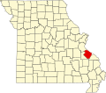
 Location of Ste. Genevieve County, Missouri | |
| Coordinates: 37°51′38″N 90°16′13″W / 37.86056°N 90.27028°W | |
| Country | United States |
| State | Missouri |
| County | Sainte Genevieve |
| Township | Union[1] |
| Elevation | 896 ft (273 m) |
| Time zone | UTC-6 (Central (CST)) |
| • Summer (DST) | UTC-5 (CDT) |
| ZIP code | 63670 |
| Area code | 573 |
| FIPS code | 29-48325 [2] |
| GNIS feature ID | 741068 |
Millers is an unincorporated community in Union Township in western Sainte Genevieve County, Missouri, United States. It is situated approximately 15 miles southwest of Ste. Genevieve.[3] The community started out as a switch spur of the Missouri-Illinois Railroad between Weingarten and Sprott on the property of L. R. Miller.[4]