Guteborn
From Wikipedia, the free encyclopedia
Guteborn | |
|---|---|
Location of Guteborn within Oberspreewald-Lausitz district 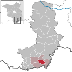 | |
 Guteborn  Guteborn | |
| Coordinates: 51°25′00″N 13°55′59″E / 51.41667°N 13.93306°E | |
| Country | Germany |
| State | Brandenburg |
| District | Oberspreewald-Lausitz |
| Municipal assoc. | Ruhland |
| Government | |
| • Mayor (2024–29) | Ralf Pavlik[1] |
| Area | |
• Total | 16.65 km2 (6.43 sq mi) |
| Elevation | 114 m (374 ft) |
| Population (2022-12-31)[2] | |
• Total | 522 |
| • Density | 31/km2 (81/sq mi) |
| Time zone | UTC+01:00 (CET) |
| • Summer (DST) | UTC+02:00 (CEST) |
| Postal codes | 01945 |
| Dialling codes | 035752 |
| Vehicle registration | OSL |
| Website | www.amt-ruhland.de |
Guteborn (Upper Sorbian Wudwor; Lower Sorbian: Dobryborn) is a municipality in the Oberspreewald-Lausitz district of Upper Lusatia, Brandenburg, Germany.

