Oberspreewald-Lausitz
District in Brandenburg, Germany
From Wikipedia, the free encyclopedia
Oberspreewald-Lausitz (Lower Sorbian: Wokrejs Górne Błota-Łužyca, Upper Sorbian: Wokrjes Hornje Błóta-Łužica [ˈwɔkʁʲɛs ˈhɔʁnʲɛ ˈbwʊta ˈwuʒitsa]) is a Kreis (district) in the southern part of Brandenburg, Germany. Neighboring districts are (from the north clockwise) Dahme-Spreewald, Spree-Neiße, the districts Bautzen and Meissen in Saxony, and the district Elbe-Elster.
Oberspreewald-Lausitz Wokrejs Górne Błota-Łužyca Wokrjes Hornje Błóta-Łužica | |
|---|---|
 Flag  Coat of arms | |
 | |
| Country | Germany |
| State | Brandenburg |
| Capital | Senftenberg |
| Government | |
| • District admin. | Siegurd Heinze |
| Area | |
• Total | 1,216.6 km2 (469.7 sq mi) |
| Population (31 December 2024)[1] | |
• Total | 107,793 |
| • Density | 88.602/km2 (229.48/sq mi) |
| Time zone | UTC+01:00 (CET) |
| • Summer (DST) | UTC+02:00 (CEST) |
| Vehicle registration | OSL, CA, SFB |
| Website | www |
Geography
History
The district was formed in 1993 by merging the previous districts of Calau and Senftenberg and a small part of the district Bad Liebenwerda.
Demography
 Development of Population since 1875 within the Current Boundaries (Blue Line: Population; Dotted Line: Comparison to Population Development of Brandenburg state)
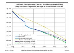 Recent Population Development and Projections (Population Development before Census 2011 (blue line); Recent Population Development according to the Census in Germany in 2011 (blue bordered line); Official projections for 2005-2030 (yellow line); for 2014-2030 (red line); for 2017-2030 (scarlet line)

Landkreis Oberspreewald-Lausitz: Population development within the current boundaries (2019)[2] | ||||||||||||||||||||||||||||||||||||||||||||||||||||||||||||||||||||||||||||||||||||||||||||||||||||||||||||||||||||||||||||||||||||||||||||
|
|
| ||||||||||||||||||||||||||||||||||||||||||||||||||||||||||||||||||||||||||||||||||||||||||||||||||||||||||||||||||||||||||||||||||||||||||
Coat of arms

The coat of arms shows a red bull as the symbol of the Lower Lusatia region, representing the former district Calau. The city wall in the bottom part is an old symbol of the Upper Lusatia region, and also represents the former district Senftenberg. The shield with a lion is the symbol of the county of Meißen, representing the municipalities of the former district Bad Liebenwerda which were included into the district.
Towns and municipalities

| Amt-free towns | Ämter | |
|---|---|---|
|
1. Altdöbern 2. Ortrand |
3. Ruhland |
| 1seat of the Amt; 2town | ||
