Heroldsberg
From Wikipedia, the free encyclopedia
Heroldsberg | |
|---|---|
 Heroldsberg seen from the west | |
 Coat of arms | |
Location of Heroldsberg
within Erlangen-Höchstadt district 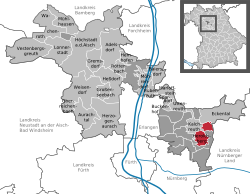 | |
 Location of Heroldsberg | |
 Heroldsberg  Heroldsberg | |
| Coordinates: 49°32′N 11°9′E / 49.533°N 11.150°E | |
| Country | Germany |
| State | Bavaria |
| Admin. region | Mittelfranken |
| District | Erlangen-Höchstadt |
| Government | |
| • Mayor (2020–26) | Jan König[1] (CSU) |
| Area | |
• Total | 11.02 km2 (4.25 sq mi) |
| Highest elevation | 378 m (1,240 ft) |
| Lowest elevation | 335 m (1,099 ft) |
| Population (2024-12-31)[2] | |
• Total | 8,281 |
| • Density | 751.5/km2 (1,946/sq mi) |
| Time zone | UTC+01:00 (CET) |
| • Summer (DST) | UTC+02:00 (CEST) |
| Postal codes | 90562 |
| Dialling codes | 0911, 09126 (Groß- and Kleingeschaidt) |
| Vehicle registration | ERH |
| Website | www.heroldsberg.de |
Heroldsberg (East Franconian: Herldsbärch) is a municipality in the district of Erlangen-Höchstadt, in Bavaria, Germany. It is located eleven kilometers north-east from the city of Nuremberg and 23 kilometers east from Erlangen and is the headquarters of Schwan-Stabilo.
Location
It is in the Sebalder Reichswald, the forest north to Nuremberg and is on a ridge. The Gründlach, a side river of the Regnitz, flows through the village of Heroldsberg.
Municipality
It contains Großgeschaidt, Kleingeschaidt and the villages of Heroldsberg, consisting of Heroldsberg, Johannisthal and Hundsmühle.[3]
Surrounding Municipalities
It is surrounded by Eckental, Lauf an der Pegnitz, Nuremberg and Kalchreuth.


