Itasca Township, Sherman County, Kansas
From Wikipedia, the free encyclopedia
Itasca Township | |
|---|---|
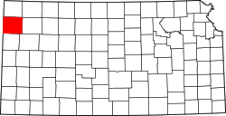
 Location in Sherman County | |
| Coordinates: 39°18′15″N 101°40′12″W / 39.30417°N 101.67000°W | |
| Country | United States |
| State | Kansas |
| County | Sherman |
| Area | |
• Total | 33.73 sq mi (87.35 km2) |
| • Land | 33.73 sq mi (87.35 km2) |
| • Water | 0 sq mi (0 km2) 0% |
| Elevation | 3,661 ft (1,116 m) |
| Population (2000) | |
• Total | 321 |
| • Density | 9.6/sq mi (3.7/km2) |
| ZIP code | 67735 |
| GNIS feature ID | 0471248 |
Itasca Township is one of the thirteen townships of Sherman County, Kansas, United States. The population was 321 at the 2000 census.[1]
Located in the center of the county, it borders the following townships:[2]
- Voltaire Township — north
- Washington Township — east
- Iowa Township — southeastern corner
- Smoky Township — south
- Logan Township — west
It lies south of the county seat of Goodland. While part of Goodland lies within the township's original boundaries,[3] the city is not part of the township.[2] There are no communities in the township proper.[3]
The intermittent source of the south fork of Sappa Creek is located in Itasca Township.[3]