Kaarina
Town in Southwest Finland, Finland
From Wikipedia, the free encyclopedia
Kaarina (Finnish pronunciation: [ˈkɑːrinɑ]; Swedish: S:t Karins, i.e. "Saint Catherine's") is a town in Finland, located in the region of Southwest Finland. It lies south of the regional capital, Turku. The population of Kaarina is approximately 37,000, while the sub-region has a population of approximately 356,000. It is the 31st most populous municipality in Finland, and the second largest municipality in the Southwest Finland region after Turku.
Kaarina
S:t Karins | |
|---|---|
Town | |
| Kaarinan kaupunki S:t Karins stad | |
 | |
 Coat of arms | |
 Location of Kaarina in Finland | |
 Interactive map of Kaarina | |
| Coordinates: 60°24′N 022°22′E | |
| Country | |
| Region | Southwest Finland |
| Sub-region | Turku sub-region |
| Metropolitan area | Turku metropolitan area |
| Charter | 1869 |
| Government | |
| • Town manager | Harri Virta |
| Area (2018-01-01)[1] | |
• Total | 179.58 km2 (69.34 sq mi) |
| • Land | 150.57 km2 (58.14 sq mi) |
| • Water | 29.15 km2 (11.25 sq mi) |
| • Rank | 276th largest in Finland |
| Population (2025-12-31)[2] | |
• Total | 36,675 |
| • Rank | 31st largest in Finland |
| • Density | 243.57/km2 (630.8/sq mi) |
| Population by native language | |
| • Finnish | 88% (official) |
| • Swedish | 5.1% |
| • Others | 6.9% |
| Population by age | |
| • 0 to 14 | 18.5% |
| • 15 to 64 | 60.3% |
| • 65 or older | 21.2% |
| Time zone | UTC+02:00 (EET) |
| • Summer (DST) | UTC+03:00 (EEST) |
| Climate | Dfb |
| Website | kaarina |
Kaarina has an area of 179.58 square kilometres (69.34 sq mi) of which 29.15 km2 (11.25 sq mi) is water.[1] The population density is 243.57 inhabitants per square kilometre (630.8/sq mi).
The municipality is unilingual Finnish, with a Swedish minority and a Swedish comprehensive school. Bilingualism was proposed but rejected in 2015.
The famous artist Tom of Finland was born in Kaarina. Kaarina has a football team called Kaarinan Pojat. The Kino Piispanristi[5] is the largest independent cinema in Southwest Finland.
The municipality of Kuusisto was merged with Kaarina in 1946. The municipality of Piikkiö was merged with Kaarina in 2009. At the same time, Kaarina adopted Piikkiö's coat of arms.
Climate
| Climate data for Kaarina Yltöinen (1991-2020 normals, extremes 1959- present) | |||||||||||||
|---|---|---|---|---|---|---|---|---|---|---|---|---|---|
| Month | Jan | Feb | Mar | Apr | May | Jun | Jul | Aug | Sep | Oct | Nov | Dec | Year |
| Record high °C (°F) | 8.8 (47.8) |
10.0 (50.0) |
14.1 (57.4) |
22.9 (73.2) |
29.3 (84.7) |
31.2 (88.2) |
33.2 (91.8) |
32.2 (90.0) |
28.0 (82.4) |
18.6 (65.5) |
14.1 (57.4) |
11.0 (51.8) |
33.2 (91.8) |
| Mean maximum °C (°F) | 4.9 (40.8) |
4.9 (40.8) |
9.2 (48.6) |
17.0 (62.6) |
24.4 (75.9) |
26.1 (79.0) |
28.3 (82.9) |
26.8 (80.2) |
21.7 (71.1) |
15.1 (59.2) |
9.5 (49.1) |
6.0 (42.8) |
29.0 (84.2) |
| Mean daily maximum °C (°F) | −0.9 (30.4) |
−1.1 (30.0) |
2.8 (37.0) |
8.9 (48.0) |
15.4 (59.7) |
19.6 (67.3) |
22.5 (72.5) |
21.3 (70.3) |
16.1 (61.0) |
9.3 (48.7) |
4.1 (39.4) |
1.1 (34.0) |
9.9 (49.8) |
| Daily mean °C (°F) | −3.6 (25.5) |
−4.3 (24.3) |
−1.3 (29.7) |
4.0 (39.2) |
10.0 (50.0) |
14.5 (58.1) |
17.5 (63.5) |
16.2 (61.2) |
11.5 (52.7) |
6.0 (42.8) |
1.9 (35.4) |
−1.3 (29.7) |
5.9 (42.6) |
| Mean daily minimum °C (°F) | −6.9 (19.6) |
−7.9 (17.8) |
−5.2 (22.6) |
−0.5 (31.1) |
4.3 (39.7) |
9.1 (48.4) |
12.2 (54.0) |
11.2 (52.2) |
7.2 (45.0) |
2.8 (37.0) |
−0.7 (30.7) |
−4.1 (24.6) |
1.8 (35.2) |
| Mean minimum °C (°F) | −20.8 (−5.4) |
−20.4 (−4.7) |
−16.3 (2.7) |
−6.9 (19.6) |
−3.0 (26.6) |
2.2 (36.0) |
6.3 (43.3) |
4.3 (39.7) |
−0.8 (30.6) |
−5.8 (21.6) |
−10.2 (13.6) |
−15.4 (4.3) |
−24.2 (−11.6) |
| Record low °C (°F) | −36.7 (−34.1) |
−37.4 (−35.3) |
−30.0 (−22.0) |
−18.4 (−1.1) |
−7.2 (19.0) |
−2.5 (27.5) |
2.0 (35.6) |
−0.6 (30.9) |
−8.0 (17.6) |
−16.8 (1.8) |
−23.5 (−10.3) |
−35.8 (−32.4) |
−37.4 (−35.3) |
| Average precipitation mm (inches) | 54 (2.1) |
41 (1.6) |
37 (1.5) |
32 (1.3) |
35 (1.4) |
57 (2.2) |
71 (2.8) |
78 (3.1) |
56 (2.2) |
74 (2.9) |
67 (2.6) |
68 (2.7) |
671 (26.4) |
| Average precipitation days (≥ 0.1 mm) | 19 | 15 | 13 | 11 | 10 | 12 | 13 | 14 | 13 | 16 | 18 | 20 | 174 |
| Average relative humidity (%) | 92 | 89 | 82 | 75 | 71 | 73 | 77 | 81 | 85 | 89 | 93 | 92 | 83 |
| Source 1: https://helda.helsinki.fi/items/d7ce3a4f-bf47-4453-be76-2a0de738c59a | |||||||||||||
| Source 2: https://kilotavu.com/asema-taulukko.php?asema=100934 [6] | |||||||||||||
Demographics
Population
The city of Kaarina has 36,675 inhabitants, making it the 31st most populous municipality in Finland. The city of Kaarina is part of the Turku region, which is the third largest urban area in Finland with 355,791 inhabitants.
| Year | Population |
|---|---|
| 1990 | |
| 1995 | |
| 2000 | |
| 2005 | |
| 2010 | |
| 2015 | |
| 2020 | |
| 2025 |
Languages
mother tongue (2025)[7]
- Finnish (88.0%)
- Swedish (5.10%)
- Russian (1.00%)
- Arabic (0.70%)
- Estonian (0.60%)
- Albanian (0.50%)
- Vietnamese (0.50%)
- Other (3.60%)
Kaarina is a monolingual Finnish-speaking municipality. The majority of the population, 32,265 persons (88%), spoke Finnish as their first language. In addition, the number of Swedish speakers was 1,877 persons (5.1%) of the population. Foreign languages were spoken by 6.9% of the population.[7] As English and Swedish are compulsory school subjects, functional bilingualism or trilingualism acquired through language studies is not uncommon.
At least 30 different languages are spoken in Kaarina. The most common foreign languages are Russian (1.0%), Arabic (0.7%), Estonian (0.6%) and Albanian (0.5%).[7]
Politics
Results of the 2011 Finnish parliamentary election in Kaarina:
- National Coalition Party 29.7%
- Social Democratic Party 21.2%
- True Finns 17.8%
- Left Alliance 9.5%
- Green League 7.1%
- Centre Party 6.6%
- Swedish People's Party 3.4%
- Christian Democrats 2.8%
Gallery
 Residential blocks in Kaarina
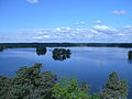 Lake Littoistenjärvi
 Dance pavilion in Littoinen
 Ravattula


