Konzell
From Wikipedia, the free encyclopedia
Konzell | |
|---|---|
 Church of Saint Martin | |
 Coat of arms | |
Location of Konzell
within Straubing-Bogen district 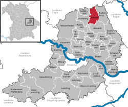 | |
 Location of Konzell | |
 Konzell  Konzell | |
| Coordinates: 49°4′N 12°43′E / 49.067°N 12.717°E | |
| Country | Germany |
| State | Bavaria |
| Admin. region | Niederbayern |
| District | Straubing-Bogen |
| Government | |
| • Mayor (2020–26) | Hans Kienberger[1] (CSU) |
| Area | |
• Total | 26.75 km2 (10.33 sq mi) |
| Highest elevation | 900 m (3,000 ft) |
| Lowest elevation | 500 m (1,600 ft) |
| Population (2023-12-31)[2] | |
• Total | 1,869 |
| • Density | 69.87/km2 (181.0/sq mi) |
| Time zone | UTC+01:00 (CET) |
| • Summer (DST) | UTC+02:00 (CEST) |
| Postal codes | 94357 |
| Dialling codes | 09963 |
| Vehicle registration | SR |
| Website | www.konzell.de |
Konzell (German: [kɔnˈtsɛl])[3] is a municipality in the district of Straubing-Bogen in Bavaria, Germany.
Mountains
Konzell is situated in the south of the Bavarian Forest. Here is the spring of the Menach, which flows in the valley of Menach direction the Bogen.
The Gallner Berg to the south, the western summit of the Gallner, and the Kramerschopf to the east are the highest points, each reaching 710 metres. To the north is the Himmelberg at 680 metres.


