Lehigh Township, Marion County, Kansas
From Wikipedia, the free encyclopedia
Lehigh Township Marion County, Kansas | |
|---|---|
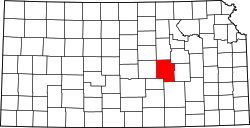
 Location within Marion County | |
 Lehigh Township Marion County, Kansas Location within the state of Kansas | |
| Coordinates: 38°23′29″N 97°19′00″W / 38.3914905°N 97.3165415°W[1] | |
| Country | United States |
| State | Kansas |
| County | Marion |
| Area | |
• Total | 36 sq mi (93 km2) |
| Dimensions | |
| • Length | 6.0 mi (9.7 km) |
| • Width | 6.0 mi (9.7 km) |
| Elevation | 1,562 ft (476 m) |
| Population | |
• Total | 311 |
| • Density | 8.6/sq mi (3.3/km2) |
| Time zone | UTC-6 (CST) |
| • Summer (DST) | UTC-5 (CDT) |
| Area code | 620 |
| FIPS code | 20-39250 [1] |
| GNIS ID | 477225 [1] |
| Website | County website |
Lehigh Township is a township in Marion County, Kansas, United States.[1] As of the 2020 census, the township population was 311, including the city of Lehigh.[2]
Lehigh Township covers an area of 36 square miles (93.2 km2).
Communities
Cemeteries
The township contains the following cemeteries:
Transportation
K-15 and U.S. Route 56 highways pass through the township.[4]