Milton Township, Marion County, Kansas
From Wikipedia, the free encyclopedia
Milton Township Marion County, Kansas | |
|---|---|
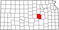
 Location within Marion County | |
 Milton Township Marion County, Kansas Location within the state of Kansas | |
| Coordinates: 38°07′45″N 96°53′11″W / 38.1292350°N 96.8863068°W[1] | |
| Country | United States |
| State | Kansas |
| County | Marion |
| Area | |
• Total | 30 sq mi (78 km2) |
| Dimensions | |
| • Length | 6.0 mi (9.7 km) |
| • Width | 5.0 mi (8.0 km) |
| Elevation | 1,453 ft (443 m) |
| Population | |
• Total | 323 |
| • Density | 11/sq mi (4.2/km2) |
| Time zone | UTC-6 (CST) |
| • Summer (DST) | UTC-5 (CDT) |
| Area code | 620 |
| FIPS code | 20-46900 [1] |
| GNIS ID | 477790 [1] |
| Website | County website |
Milton Township is a township in Marion County, Kansas, United States.[1] As of the 2020 census, the township population was 323, including the city of Burns.[2]
Milton Township covers an area of 36 square miles (93.2 km2).
Cities and towns
The township contains the following settlements:
- City of Burns.
Cemeteries
Transportation
U.S. Route 77 highway passes northwest to southeast through the township, and follows roughly parallel to the old railway.[5]