Marlborough (CDP), New Hampshire
From Wikipedia, the free encyclopedia
Marlborough, New Hampshire | |
|---|---|
 Odd Fellows Hall | |
 Marlborough  Marlborough | |
| Coordinates: 42°54′18″N 72°12′42″W / 42.90500°N 72.21167°W | |
| Country | United States |
| State | New Hampshire |
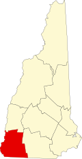
| County | Cheshire |
| Town | Marlborough |
| Area | |
• Total | 1.69 sq mi (4.37 km2) |
| • Land | 1.69 sq mi (4.37 km2) |
| • Water | 0 sq mi (0.00 km2) |
| Elevation | 712 ft (217 m) |
| Population (2020) | |
• Total | 1,066 |
| • Density | 631.9/sq mi (243.99/km2) |
| Time zone | UTC-5 (Eastern (EST)) |
| • Summer (DST) | UTC-4 (EDT) |
| ZIP code | 03455 |
| Area code | 603 |
| FIPS code | 33-45380 |
| GNIS feature ID | 2378080[2] |
Marlborough is a census-designated place (CDP) and the main village in the town of Marlborough, New Hampshire, United States. The population of the CDP was 1,066 at the 2020 census,[3] out of 2,096 in the entire town.