McGregor, North Dakota
From Wikipedia, the free encyclopedia
McGregor | |
|---|---|
 Post office in McGregor | |
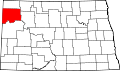
 McGregor Location within the state of North Dakota  McGregor McGregor (the United States) | |
| Coordinates: 48°35′44″N 102°55′41″W / 48.59556°N 102.92806°W | |
| Country | United States |
| State | North Dakota |
| County | Williams |
| Area | |
• Total | 0.13 sq mi (0.33 km2) |
| • Land | 0.13 sq mi (0.33 km2) |
| • Water | 0 sq mi (0.00 km2) |
| Elevation | 2,218 ft (676 m) |
| Population (2020) | |
• Total | 47 |
| • Density | 372.8/sq mi (143.94/km2) |
| Time zone | UTC-6 (Central (CST)) |
| • Summer (DST) | UTC-5 (CDT) |
| ZIP codes | 58755 |
| Area code | 701 |
| FIPS code | 38-49220 |
| GNIS feature ID | 2805290[2] |
McGregor is an unincorporated community and census-designated place (CDP) in northeastern Williams County, North Dakota, United States. It lies along North Dakota Highway 40, northeast of the city of Williston, the county seat of Williams County.[3] McGregor's elevation is 2,218 feet (676 m).[4] Although unincorporated, it has a post office, with the ZIP code of 58755.[5] It was first listed as a CDP prior to the 2020 census. As of the 2020 census, McGregor had a population of 47.[6]