Medill, Missouri
From Wikipedia, the free encyclopedia
Medill, Missouri | |
|---|---|
 Interactive map of Medill, Missouri | |
| Coordinates: 40°25′48″N 91°46′27″W / 40.43000°N 91.77417°W[1] | |
| Country | United States |
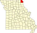
| State | Missouri |
| County | Clark |
| Area | |
• Total | 0.78 sq mi (2.03 km2) |
| • Land | 0.78 sq mi (2.02 km2) |
| • Water | 0.0039 sq mi (0.01 km2) |
| Elevation | 709 ft (216 m) |
| Population (2020) | |
• Total | 82 |
| • Density | 105.3/sq mi (40.67/km2) |
| ZIP code | 63445[3] |
| Area code | 660 |
| FIPS code | 29-47144 |
| GNIS feature ID | 2806391[1] |
Medill is an unincorporated community and census-designated place in Clark County, in the U.S. state of Missouri.[1] As of the 2020 census, its population was 82.[4]
The community is on US Route 136, three miles west of Kahoka.[5] The Atchison, Topeka and Santa Fe Railroad passes through the community, as did the Chicago, Burlington and Quincy Railroad.[6]