Michael, Illinois
From Wikipedia, the free encyclopedia
Michael, Illinois | |
|---|---|
 Michael, Illinois  Michael, Illinois | |
| Coordinates: 39°14′07″N 90°37′24″W / 39.23528°N 90.62333°W | |
| Country | United States |
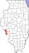
| State | Illinois |
| County | Calhoun |
| Elevation | 446 ft (136 m) |
| Time zone | UTC-6 (Central (CST)) |
| • Summer (DST) | UTC-5 (CDT) |
| ZIP Code | 62065 |
| Area code | 618 |
| GNIS feature ID | 413471[1] |
Michael is an unincorporated community in Calhoun County, Illinois, United States. The community is on Illinois Route 100 5.5 miles (8.9 km) north of Hardin.[2] Michael had a post office until September 7, 2011; it still has its own ZIP Code, 62065.[3][4] Michael, along with the rest of Calhoun County, is within Metro East and part of the Greater St. Louis area.