Mission Township, Brown County, Kansas
From Wikipedia, the free encyclopedia
Mission Township | |
|---|---|
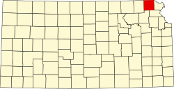
 Location in Brown County | |
| Coordinates: 39°42′46″N 095°33′06″W / 39.71278°N 95.55167°W | |
| Country | United States |
| State | Kansas |
| County | Brown |
| Area | |
• Total | 85.08 sq mi (220.36 km2) |
| • Land | 84.46 sq mi (218.75 km2) |
| • Water | 0.62 sq mi (1.61 km2) 0.73% |
| Elevation | 1,120 ft (340 m) |
| Population (2000) | |
• Total | 645 |
| • Density | 7.5/sq mi (2.9/km2) |
| GNIS feature ID | 0472980 |
Mission Township is a township in Brown County, Kansas, United States. As of the 2000 census, its population was 645.
Mission Township was formed in 1872.[1]
Geography
Mission Township covers an area of 85.08 square miles (220.4 km2). It contains one incorporated settlement, Willis, and surrounds another, the governmentally independent city of Horton. According to the USGS, it contains four cemeteries: Carr, Claytonville, Kennekuk and Saint Peters.
The stream of Hazel Creek runs through this township.