Montferland
From Wikipedia, the free encyclopedia
Montferland | |
|---|---|
 Looking towards the Montferland hills | |
 Flag Coat of arms | |
.svg) Location in Gelderland | |
| Coordinates: 51°56′N 6°8′E / 51.933°N 6.133°E | |
| Country | Netherlands |
| Province | Gelderland |
| Established | 1 January 2005[1] |
| Government | |
| • Body | Municipal council |
| • Mayor | Harry de Vries (acting) (CDA) |
| Area | |
• Total | 106.64 km2 (41.17 sq mi) |
| • Land | 105.70 km2 (40.81 sq mi) |
| • Water | 0.94 km2 (0.36 sq mi) |
| Elevation | 13 m (43 ft) |
| Highest elevation | 93 m (305 ft) |
| Population (January 2021)[6] | |
• Total | 36,031 |
| • Density | 341/km2 (880/sq mi) |
| Time zone | UTC+1 (CET) |
| • Summer (DST) | UTC+2 (CEST) |
| Postcode | 6940–6942, 7035–7048 |
| Area code | 0314, 0316 |
| Website | www |

Montferland (Dutch pronunciation: [ˈmɔntfərlɑnt] ⓘ) is a municipality in the Dutch province of Gelderland. It was created on 1 January 2005 from the amalgamation of the former municipalities of Bergh and Didam.
Gallery
 St Martin's church in Beek
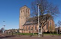 Didam church
 Kilder church
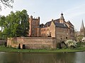 Huis Bergh castle in
's-Heerenberg Düffels Möl in Stokkum
 Windmill in Zeddam village


