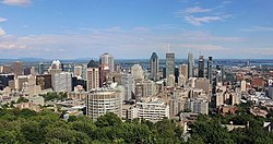
Greater Montreal
Metropolitan area in Quebec, Canada
From Wikipedia, the free encyclopedia
Greater Montreal (French: Grand Montréal, [ɡʁɑ̃ mɔ̃ʁeal]) is the most populous metropolitan area in Quebec and the second most populous in Canada after Greater Toronto. In 2015, Statistics Canada identified Montreal's Census Metropolitan Area (CMA) as 4,258.31 square kilometres (1,644.14 mi2) with a population of 4,027,100,[6] almost 50% of the province.

Greater Montreal
| ||
|---|---|---|
| ||
 Interactive Map of Greater Montreal[1]
| ||
| Country | Canada | |
| Province | Québec | |
| Area | ||
• Total | 4,739.04 km2 (1,829.75 sq mi) | |
| • Land | 4,258.31 km2 (1,644.14 sq mi) | |
| Population (2021)[3] | ||
• Total | 4,291,732 | |
| 4,597,837 | ||
| • Density | 1,007.85/km2 (2,610.3/sq mi) | |
| GDP (nominal, 2022) | ||
| • Total | CA$279 billion[5] | |
| Time zone | UTC−5 (EST) | |
| • Summer (DST) | UTC−4 (EDT) | |
| Postal code prefixes | ||
| Area codes | 263, 354, 438, 450, 514, 579 | |
 Greater Montreal shown in light blue, with the City of Montreal proper in dark blue. | ||
A smaller area of 3,838 square kilometres (1,482 mi2) is governed by the Montreal Metropolitan Community (MMC; French: Communauté métropolitaine de Montréal, CMM). This level of government is headed by a president (currently Montreal mayor Soraya Martinez Ferrada).[citation needed]
The inner ring is composed of densely populated municipalities located in close proximity to Downtown Montreal. It includes the entire Island of Montreal, Laval, and the Urban Agglomeration of Longueuil. Due to their proximity to Montreal's downtown core, some additional suburbs on the South Shore (Brossard, Saint-Lambert, and Boucherville) are usually included in the inner ring, despite their location on the mainland.[citation needed]
The outer ring is composed of low-density municipalities located on the fringe of Metropolitan Montreal. Most of these cities and towns are semi-rural. Specifically, the term banlieues hors de l'île (off-island suburbs) refers to those suburbs that are located on the North Shore of the Mille-Îles River, those on the South Shore that were never included in the megacity of Longueuil, and those on the Vaudreuil-Soulanges Peninsula.[citation needed]
Largest cities
| Rank | City | Region | Population (2021) | Land Area | Population Density | ||
|---|---|---|---|---|---|---|---|
| km2 | mi2 | /km2 | /mi2 | ||||
| 1 | Montreal | Montreal | 1,762,949 | 364.74 | 140.83 | 4,833.5 | 12,519 |
| 2 | Laval | Laval | 438,366 | 246.13 | 95.03 | 1,781.0 | 4,613 |
| 3 | Longueuil | Montérégie | 254,483 | 115.77 | 44.70 | 2,198.2 | 5,693 |
| 4 | Terrebonne | Lanaudière | 119,944 | 153.76 | 59.37 | 780.1 | 2,020 |
| 5 | Brossard | Montérégie | 91,525 | 45.19 | 17.45 | 2,025.3 | 5,246 |
| 6 | Repentigny | Lanaudière | 86,100 | 61.52 | 23.75 | 1,399.6 | 3,625 |
| 7 | Saint-Jérôme | Laurentides | 80,213 | 90.18 | 34.82 | 889.5 | 2,304 |
| 8 | Blainville | Laurentides | 59,819 | 54.97 | 21.22 | 1,088.2 | 2,818 |
| 9 | Mirabel | Laurentides | 61,108 | 484.09 | 186.91 | 126.2 | 327 |
| 10 | Dollard-des-Ormeaux | Montreal | 48,403 | 14.98 | 5.78 | 3,230.2 | 8,366 |
Cities and towns
 Montreal
 Laval
Laval Longueuil


- subdivided into the boroughs of Le Vieux-Longueuil, Saint-Hubert and Greenfield Park.
Only a portion of the municipalities and MRC's located in geographical entities highlighted in light gray are part of the CMM/CMA.
There are 82 municipalities that are part of the MMC and 91 municipalities that are part of the CMA.
There are 79 municipalities that overlap between the two, with 3 municipalities being part of the MMC but not the CMA, and 12 municipalities being part of the CMA but not the MMC.[8][9]
Kanesatake and Kahnawake are not included in the previous counts.
Demographics
| Year | Pop. | ±% |
|---|---|---|
| 1871 | 174,090 | — |
| 1881 | 223,512 | +28.4% |
| 1891 | 308,169 | +37.9% |
| 1901 | 393,665 | +27.7% |
| 1911 | 594,812 | +51.1% |
| 1921 | 774,330 | +30.2% |
| 1931 | 1,064,448 | +37.5% |
| 1941 | 1,192,235 | +12.0% |
| 1951 | 1,539,308 | +29.1% |
| 1956 | 1,745,001 | +13.4% |
| 1961 | 2,110,679 | +21.0% |
| 1966 | 2,570,985 | +21.8% |
| 1971 | 2,743,208 | +6.7% |
| 1976 | 2,802,485 | +2.2% |
| 1981 | 2,862,286 | +2.1% |
| 1986 | 2,921,357 | +2.1% |
| 1991 | 3,208,970 | +9.8% |
| 1996 | 3,326,510 | +3.7% |
| 2001 | 3,426,350 | +3.0% |
| 2006 | 3,635,571 | +6.1% |
| 2011 | 3,824,221 | +5.2% |
| 2016 | 4,098,927 | +7.2% |
| 2021 | 4,291,732 | +4.7% |
| [10] | ||
Ethnicity
| Panethnic group |
2021[11][12] | 2016[13] | 2011[14] | 2006[15] | 2001[16] | |||||
|---|---|---|---|---|---|---|---|---|---|---|
| Pop. | % | Pop. | % | Pop. | % | Pop. | % | Pop. | % | |
| European[a] | 3,059,895 | 72.74% | 3,070,210 | 76.57% | 2,963,860 | 78.98% | 2,980,280 | 83.05% | 2,911,230 | 86.11% |
| African | 340,140 | 8.09% | 270,940 | 6.76% | 216,310 | 5.76% | 169,065 | 4.71% | 139,305 | 4.12% |
| Middle Eastern[b] | 285,615 | 6.79% | 220,055 | 5.49% | 172,345 | 4.59% | 113,405 | 3.16% | 79,410 | 2.35% |
| Latin American | 137,850 | 3.28% | 110,195 | 2.75% | 98,010 | 2.61% | 75,400 | 2.1% | 53,155 | 1.57% |
| South Asian | 121,260 | 2.88% | 85,925 | 2.14% | 79,540 | 2.12% | 70,615 | 1.97% | 57,935 | 1.71% |
| East Asian[c] | 116,820 | 2.78% | 100,265 | 2.5% | 83,420 | 2.22% | 79,665 | 2.22% | 58,165 | 1.72% |
| Southeast Asian[d] | 101,560 | 2.41% | 88,755 | 2.21% | 89,645 | 2.39% | 68,475 | 1.91% | 57,460 | 1.7% |
| Indigenous | 46,085 | 1.1% | 34,745 | 0.87% | 26,285 | 0.7% | 17,865 | 0.5% | 11,085 | 0.33% |
| Other[e] | 40,565 | 0.96% | 28,710 | 0.72% | 23,060 | 0.61% | 13,755 | 0.38% | 12,900 | 0.38% |
| Total responses | 4,206,455 | 98.01% | 4,009,795 | 97.83% | 3,752,470 | 98.12% | 3,588,520 | 98.71% | 3,380,645 | 98.67% |
| Total population | 4,291,732 | 100% | 4,098,927 | 100% | 3,824,221 | 100% | 3,635,571 | 100% | 3,426,350 | 100% |
- Note: Totals greater than 100% due to multiple origin responses.
Language
| Language | Greater Montreal | Quebec | Canada |
|---|---|---|---|
| French | 65.9% | 79.1% | 21.4% |
| English | 13.2% | 8.9% | 58.1% |
| Arabic | 4.5% | 2.1% | 1.1% |
| Spanish | 3.2% | 1.8% | 1.3% |
| Italian | 2.7% | 1.6% | 1.3% |
| Creole | 1.5% | 0.8% | 0.2% |
| Mandarin | 1.0% | 0.1% | 1.8% |
| Greek | 1.0% | 0.5% | 0.4% |
| Romanian | 0.8% | 0.4% | 0.3% |
| Portuguese | 0.8% | 0.5% | 0.7% |
| Russian | 0.7% | 0.3% | 0.5% |
| Vietnamese | 0.7% | 0.4% | 0.5% |
| Persian (Farsi) | 0.6% | 0.3% | 0.5% |
| Cantonese | 0.6% | 0.1% | 1.7% |
| Tagalog (Filipino) | 0.5% | 0.2% | 1.2% |
| Armenian | 0.4% | 0.2% | 0.1% |
| Tamil | 0.4% | 0.2% | 0.4% |
| Punjabi (Panjabi) | 0.3% | 0.2% | 1.4% |
| Polish | 0.3% | 0.2% | 0.6% |
| Bengali | 0.3% | 0.1% | 0.2% |
| German | 0.3% | 0.2% | 1.3% |
| Urdu | 0.3% | 0.1% | 0.6% |
| Yiddish | 0.2% | 0.1% | <0.1% |
| Cambodian (Khmer) | 0.2% | 0.1% | <0.1% |
| Turkish | 0.2% | 0.1% | 0.1% |
| Gujarati | 0.2% | 0.1% | 0.3% |
| Hungarian | 0.2% | 0.1% | 0.2% |
| Bulgarian | 0.2% | 0.1% | 0.1% |
| Berber (Kabyle) | 0.2% | 0.1% | <0.1% |
| Unspecified Chinese | <0.1% | 0.1% | 0.1% |
Transportation

Montreal has an extensive public transit network with multiple modes of transport:
- The Montreal metro with four lines that extends into Longueuil and Laval
- The Réseau express métropolitain (REM), a separate regional light metro network, serving Brossard on the South Shore, central and western island of Montreal, western Laval, and Sainte-Dorothée on the North Shore
- Exo commuter rail with five radial lines that extend from the city centre to outlying suburban communities, primarily operating during rush hour on weekends
- Bus and paratransit service across the area: Exo, Réseau de transport de Longueuil, Société de transport de Montréal and Société de transport de Laval.
The Autorité régionale de transport métropolitain (ARTM, English: Regional Authority of Metropolitan Transportation) plans, integrates, funds and coordinates public transport across Greater Montreal.[18] The ARTM manages the integrated fare structure and Opus fare payment system.[19][20][21] It owns major reserved bus lanes, metropolitan bus terminuses and park-and-ride lots, and oversees major transit projects. The ARTM budget ($248 million in 2026) provides funding to transit agencies for operations.[22]
Education
| Universities | CEGEPs and other colleges | Other schools |
|---|---|---|
|
(In Montreal, except where otherwise noted.)
See also
Notes
- 2001-2016: Statistic includes all persons that did not make up part of a visible minority or an indigenous identity.
2021: Statistic includes all persons belonging to the non-indigenous and non-visible minority "White" population group. - Statistic includes total responses of "West Asian" and "Arab" under visible minority section on census.
- Statistic includes total responses of "Chinese", "Korean", and "Japanese" under visible minority section on census.
- Statistic includes total responses of "Filipino" and "Southeast Asian" under visible minority section on census.
- Statistic includes total responses of "Visible minority, n.i.e." and "Multiple visible minorities" under visible minority section on census.
- Group 1
- Group 2
- classified as an equivalent territory
- Group 3
- in area served by the Réseau de transport métropolitain