Pendroy, Montana
From Wikipedia, the free encyclopedia
Pendroy, Montana | |
|---|---|
  Pendroy, Montana  Pendroy, Montana | |
| Coordinates: 48°04′23″N 112°17′57″W / 48.07306°N 112.29917°W | |
| Country | United States |
| State | Montana |
| County | Teton |
| Area | |
• Total | 0.17 sq mi (0.43 km2) |
| • Land | 0.17 sq mi (0.43 km2) |
| • Water | 0 sq mi (0.00 km2) |
| Elevation | 4,272 ft (1,302 m) |
| Population (2020) | |
• Total | 25 |
| • Density | 150.2/sq mi (57.98/km2) |
| Time zone | UTC-7 (Mountain (MST)) |
| • Summer (DST) | UTC-6 (MDT) |
| ZIP code | 59467 |
| Area code | 406 |
| GNIS feature ID | 2806671[2]U.S. Geological Survey Geographic Names Information System: Pendroy, Montana |
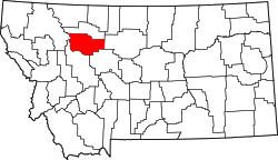
Pendroy is an unincorporated community in Teton County, Montana, United States.[2] Its ZIP code is 59467.[3] As of the 2020 census, Pendroy had a population of 25.[4]
Established with the construction of the Great Northern Railway, the town boasted a depot, roundhouse, and section house by 1916. It is named for nearby homesteader Levi "Boots" Pendroy, friend of railway founder James J. Hill.[5]