Rockport Colony, Montana
From Wikipedia, the free encyclopedia
CountryUnited States
Elevation4,410 ft (1,340 m)
Rockport Colony, Montana | |
|---|---|
  Rockport Colony  Rockport Colony | |
| Coordinates: 48°4′0″N 112°28′32″W / 48.06667°N 112.47556°W | |
| Country | United States |
| State | Montana |
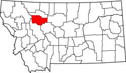
| County | Teton |
| Area | |
• Total | 0.22 sq mi (0.57 km2) |
| • Land | 0.22 sq mi (0.57 km2) |
| • Water | 0 sq mi (0.00 km2) |
| Elevation | 4,410 ft (1,340 m) |
| Population (2020) | |
• Total | 0 |
| • Density | 0/sq mi (0/km2) |
| Time zone | UTC-7 (Mountain (MST)) |
| • Summer (DST) | UTC-6 (MDT) |
| ZIP Code | 59467 (Pendroy) |
| Area code | 406 |
| FIPS code | 30-63590 |
| GNIS feature ID | 2806672[2] |
Rockport Colony is a Hutterite community[3] and census-designated place (CDP) in Teton County, Montana, United States. It is in the northern part of the county, 10 miles (16 km) south of Dupuyer and 25 miles (40 km) northwest of Choteau, the Teton county seat.
Rockport Colony was first listed as a CDP prior to the 2020 census.[2] As of the 2020 census, Rockport Colony had a population of 0.[4]