Sardis, Arkansas
From Wikipedia, the free encyclopedia
CountryUnited States
Elevation364 ft (111 m)
Sardis, Arkansas | |
|---|---|
 Sardis, Arkansas  Sardis, Arkansas | |
| Coordinates: 34°31′59″N 92°24′24″W / 34.53306°N 92.40667°W | |
| Country | United States |
| State | Arkansas |
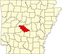
| County | Saline |
| Elevation | 364 ft (111 m) |
| Population (2020) | |
• Total | 833 |
| Time zone | UTC-6 (Central (CST)) |
| • Summer (DST) | UTC-5 (CDT) |
| GNIS feature ID | 2805685[1] |
Sardis is an unincorporated community and census-designated place (CDP) in southeast Saline County, Arkansas, United States.[1] It is part of the Little Rock-North Little Rock-AR Metropolitan Statistical Area. It was first listed as a CDP in the 2020 census with a population of 833.[2]
The community is approximately six miles east-southeast of Bauxite and four miles southwest of East End. Hurricane Creek flows past approximately one mile west of the site.[3]
Sardis is part of the Bryant Public School District.