Steffenberg
From Wikipedia, the free encyclopedia
Steffenberg | |
|---|---|
 Coat of arms | |
Location of Steffenberg within Marburg-Biedenkopf district 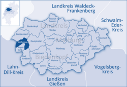 | |
 Steffenberg  Steffenberg | |
| Coordinates: 50°51′N 08°28′E / 50.850°N 8.467°E | |
| Country | Germany |
| State | Hesse |
| Admin. region | Gießen |
| District | Marburg-Biedenkopf |
| Government | |
| • Mayor (2022–28) | Gernot Wege[1] (Ind.) |
| Area | |
• Total | 24.3 km2 (9.4 sq mi) |
| Highest elevation | 550 m (1,800 ft) |
| Lowest elevation | 330 m (1,080 ft) |
| Population (2023-12-31)[2] | |
• Total | 3,835 |
| • Density | 160/km2 (410/sq mi) |
| Time zone | UTC+01:00 (CET) |
| • Summer (DST) | UTC+02:00 (CEST) |
| Postal codes | 35239 |
| Dialling codes | 06464 |
| Vehicle registration | MR |
| Website | www.steffenberg.de |
Steffenberg (German pronunciation: [ˈʃtɛfn̩bɛʁk]) is a municipality in Marburg-Biedenkopf district in Hesse, Germany.
Location
Steffenberg lies at the southern foothills of the Rothaargebirge between the towns of Dillenburg (20 km) and Marburg (35 km).
Neighbouring municipalities
Steffenberg borders in the north on the municipality of Breidenbach, in the east on the municipality of Dautphetal, in the south on the municipalities of Bad Endbach and Angelburg (all in Marburg-Biedenkopf), and in the west on the municipality of Eschenburg (Lahn-Dill-Kreis).
Divisions
The municipality consists of the following six centres:
- Niedereisenhausen
- Oberhörlen
- Quotshausen
- Steinperf
- Obereisenhausen
- Niederhörlen
