Stowe (CDP), Vermont
From Wikipedia, the free encyclopedia
Stowe, Vermont | |
|---|---|
 Stowe, VT, from the southeast | |
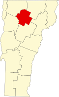
 Stowe Location in Vermont  Stowe Location in the United States | |
| Coordinates: 44°27′55″N 72°41′8″W / 44.46528°N 72.68556°W | |
| Country | United States |
| State | Vermont |
| County | Lamoille |
| Town | Stowe |
| Area | |
• Total | 0.82 sq mi (2.13 km2) |
| • Land | 0.81 sq mi (2.11 km2) |
| • Water | 0.0077 sq mi (0.02 km2) |
| Elevation | 723 ft (220 m) |
| Population | |
• Total | 495 |
| • Density | 608/sq mi (234.6/km2) |
| Time zone | UTC−5 (Eastern (EST)) |
| • Summer (DST) | UTC−4 (EDT) |
| ZIP Code | 05672 |
| Area code | 802 |
| FIPS code | 50-70450[1] |
| GNIS feature ID | 2586656[3] |
Stowe is a census-designated place (CDP) comprising the central community in the town of Stowe, Lamoille County, Vermont, United States. As of the 2010 census the population of the CDP was 495,[2] out of 4,314 in the entire town.