Stutfield Peak
From Wikipedia, the free encyclopedia
| Stutfield Peak | |
|---|---|
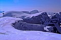
 Stutfield's East Peak seen from the Skywalk area | |
| Highest point | |
| Elevation | 3,450 m (11,320 ft)[1] |
| Prominence | 290 m (950 ft)[2] |
| Parent peak | North Twin Peak (3730 m)[2] |
| Listing | Mountains of Alberta |
| Coordinates | 52°14′18″N 117°24′27″W / 52.23833°N 117.40750°W[3] |
| Geography | |
 Stutfield Peak Location in Alberta | |
| Country | Canada |
| Province | Alberta |
| Parent range | Winston Churchill Range |
| Topo map | NTS 83C3 Columbia Icefield[3] |
| Climbing | |
| First ascent | 1927 by Alfred J. Ostheimer, guided by Hans Fuhrer[1][2] |
| Easiest route | rock/snow climb |
Stutfield Peak is a mountain in Jasper National Park, Alberta, Canada. It is located at the northern end of the Columbia Icefield, 6 kilometres (3.7 mi) north-west from Mount Kitchener, in the Winston Churchill Range of the Canadian Rockies. The peak has two summits - Stutfield East and Stutfield West - and is therefore sometimes referred to as The Stutfields. The West peak is higher than the East peak by 50 m (164 ft).[1]
In 1899, mountaineer J. Norman Collie named the mountain after Hugh Stutfield, who climbed with Collie during his exploration of the Canadian Rockies.[1]
Stufield Glacier was also named after Hugh Stutfield, and flows southeast from the peak, in the Columbia Icefield.
Based on the Köppen climate classification, it is located in a subarctic climate with cold, snowy winters, and mild summers.[4] Temperatures can drop below −20 °C (−4 °F) with wind chill factors below −30 °C (−22 °F).
Gallery
 The Stutfields (W & E); Mount Alberta at back
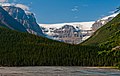 Stutfield Glacier from Icefields Parkway Viewpoint
;_Mt._Alberta_at_back.jpg)
