Turtle River Township, North Dakota
From Wikipedia, the free encyclopedia
Elevation814 ft (248 m)
Turtle River Township, North Dakota | |
|---|---|
  Turtle River Township | |
| Coordinates: 48°08′59″N 97°11′27″W / 48.14972°N 97.19083°W | |
| Country |  United States United States |
| State |  North Dakota North Dakota |
| County | Grand Forks |
| Area | |
• Total | 33.54 sq mi (86.87 km2) |
| • Land | 33.27 sq mi (86.16 km2) |
| • Water | 0.27 sq mi (0.7 km2) |
| Elevation | 814 ft (248 m) |
| Population | |
• Total | 163 |
| • Density | 4.90/sq mi (1.89/km2) |
| Time zone | UTC-6 (Central (CST)) |
| • Summer (DST) | UTC-5 (CDT) |
| ZIP codes | |
| Area code | 701 |
| FIPS code | 38-80060 |
| GNIS feature ID | 1036622[2] |
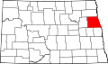
Turtle River Township is a township located in the northeastern-most corner of Grand Forks County, North Dakota, United States. The population was 163 at the 2020 census. The township borders Minnesota to its east.
It was named after the river that flows through it.[3]