Valserhône
From Wikipedia, the free encyclopedia
Valserhône | |
|---|---|
Commune | |
 | |
 Location of Valserhône | |
 Valserhône  Valserhône | |
| Coordinates: 46°06′30″N 5°49′36″E / 46.1083°N 5.8267°E | |
| Country | France |
| Region | Auvergne-Rhône-Alpes |
| Department | Ain |
| Arrondissement | Nantua |
| Canton | Valserhône |
| Intercommunality | Terre Valserhône |
| Government | |
| • Mayor (2020–2026) | Régis Petit[1] |
Area 1 | 62.54 km2 (24.15 sq mi) |
| Population (2023)[2] | 16,712 |
| • Density | 267.2/km2 (692.1/sq mi) |
| Time zone | UTC+01:00 (CET) |
| • Summer (DST) | UTC+02:00 (CEST) |
| INSEE/Postal code | 01033 /01200 |
| Elevation | 330–1,606 m (1,083–5,269 ft) (avg. 485 m or 1,591 ft) |
| 1 French Land Register data, which excludes lakes, ponds, glaciers > 1 km2 (0.386 sq mi or 247 acres) and river estuaries. | |
Valserhône (French pronunciation: [valsəʁon] ⓘ; Arpitan: Vâlcerôno) is a commune in the Ain department in the Auvergne-Rhône-Alpes region in Eastern France. It is the result of the merger, on 1 January 2019, of the communes of Bellegarde-sur-Valserine, Châtillon-en-Michaille and Lancrans.[3] In 2018, the three communes had a combined population of 16,431, with Bellegarde-sur-Valserine as the major population centre. This makes Valserhône the third-most populated commune of Ain, after Bourg-en-Bresse and Oyonnax.
Climate
Valserhône is located at the confluence of the Valserine and the Rhône. It was named after the two rivers. The commune is part of Haut-Jura Regional Natural Park.
The commune has a station, Bellegarde, which is located at the junction of three railway lines and has regular service to various destinations in France and Switzerland.
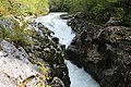 The Valserine in Valserhône
 Église Saint-Paul de Vouvray in Châtillon-en-Michaille
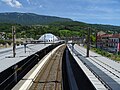
.jpg)


Valserhône has an oceanic climate (Köppen climate classification Cfb). The average annual temperature in Valserhône is 11.1 °C (52.0 °F). The average annual rainfall is 1,184.6 mm (46.64 in) with December as the wettest month. The temperatures are highest on average in July, at around 20.4 °C (68.7 °F), and lowest in January, at around 2.1 °C (35.8 °F). The highest temperature ever recorded in Valserhône was 39.5 °C (103.1 °F) on 13 August 2003; the coldest temperature ever recorded was −17.0 °C (1.4 °F) on 5 February 2012.
| Climate data for Bellegarde-sur-Valserine, Valserhône, Ain, France, Alt. : 350 m, (1991-2020 averages, extremes 1994−present) | |||||||||||||
|---|---|---|---|---|---|---|---|---|---|---|---|---|---|
| Month | Jan | Feb | Mar | Apr | May | Jun | Jul | Aug | Sep | Oct | Nov | Dec | Year |
| Record high °C (°F) | 16.5 (61.7) |
20.2 (68.4) |
25.4 (77.7) |
29.6 (85.3) |
33.8 (92.8) |
36.5 (97.7) |
38.6 (101.5) |
39.5 (103.1) |
32.7 (90.9) |
28.0 (82.4) |
22.9 (73.2) |
16.4 (61.5) |
39.5 (103.1) |
| Mean daily maximum °C (°F) | 5.9 (42.6) |
8.3 (46.9) |
13.0 (55.4) |
17.1 (62.8) |
21.0 (69.8) |
25.2 (77.4) |
27.5 (81.5) |
26.9 (80.4) |
22.3 (72.1) |
17.2 (63.0) |
10.5 (50.9) |
6.2 (43.2) |
16.8 (62.2) |
| Daily mean °C (°F) | 2.1 (35.8) |
3.4 (38.1) |
7.0 (44.6) |
10.7 (51.3) |
14.7 (58.5) |
18.5 (65.3) |
20.4 (68.7) |
20.0 (68.0) |
16.0 (60.8) |
11.9 (53.4) |
6.3 (43.3) |
2.7 (36.9) |
11.1 (52.0) |
| Mean daily minimum °C (°F) | −1.7 (28.9) |
−1.4 (29.5) |
1.1 (34.0) |
4.3 (39.7) |
8.4 (47.1) |
11.7 (53.1) |
13.4 (56.1) |
13.0 (55.4) |
9.7 (49.5) |
6.6 (43.9) |
2.1 (35.8) |
−0.9 (30.4) |
5.5 (41.9) |
| Record low °C (°F) | −15.4 (4.3) |
−17.0 (1.4) |
−13.7 (7.3) |
−5.4 (22.3) |
−1.4 (29.5) |
2.3 (36.1) |
5.3 (41.5) |
4.7 (40.5) |
0.1 (32.2) |
−5.5 (22.1) |
−10.3 (13.5) |
−16.1 (3.0) |
−17.0 (1.4) |
| Average precipitation mm (inches) | 116.3 (4.58) |
92.5 (3.64) |
88.7 (3.49) |
81.5 (3.21) |
94.2 (3.71) |
86.1 (3.39) |
86.9 (3.42) |
91.4 (3.60) |
87.4 (3.44) |
108.8 (4.28) |
118.7 (4.67) |
132.1 (5.20) |
1,184.6 (46.64) |
| Average precipitation days (≥ 1.0 mm) | 11.3 | 9.4 | 9.9 | 9.9 | 11.7 | 9.4 | 8.9 | 9.0 | 8.5 | 10.4 | 11.0 | 11.4 | 120.7 |
| Source: Meteociel[4] | |||||||||||||