Albig
From Wikipedia, the free encyclopedia
Albig | |
|---|---|
 Coat of arms | |
Location of Albig
within Alzey-Worms district 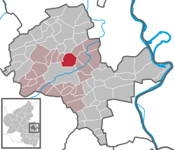 | |
 | |
| Location of Albig | |
 Albig  Albig | |
| Coordinates: 49°46′N 8°7′E / 49.767°N 8.117°E | |
| Country | Germany |
| State | Rhineland-Palatinate |
| District | Alzey-Worms |
| Municipal assoc. | Alzey-Land |
| Government | |
| • Mayor (2019–24) | Wilfried Best[1] |
| Area | |
• Total | 10.24 km2 (3.95 sq mi) |
| Elevation | 216 m (709 ft) |
| Population (2023-12-31)[2] | |
• Total | 1,634 |
| • Density | 159.6/km2 (413.3/sq mi) |
| Time zone | UTC+01:00 (CET) |
| • Summer (DST) | UTC+02:00 (CEST) |
| Postal codes | 55234 |
| Dialling codes | 06731 |
| Vehicle registration | AZ |
| Website | www.alzey-land.de |
Albig (German pronunciation: [ˈalbɪç]) is an Ortsgemeinde – a municipality belonging to a Verbandsgemeinde, a kind of collective municipality – in Rhenish Hesse in the Alzey-Worms district in Rhineland-Palatinate, Germany.
Location
The municipality lies in Rhenish Hesse and belongs to the Verbandsgemeinde of Alzey-Land, whose seat is in Alzey.
History
Traces of New Stone Age (Spiral Ceramic) and Iron Age settlers, believed to be Celts, have been found in Albig. Some finds, such as fibulae, rings and vessels from a La Tène-era grave, are displayed in the Landesmuseum Mainz. On a hill near Albig, the foundations of a Roman villa rustica were unearthed, and because it was mistakenly believed that they were a mediaeval castle ruin, they were named Schloss Hammerstein, “Schloss” being a German word for castle.
Albig had its first documentary mention in 767 in a document donating a vineyard to Lorsch Abbey.
Since 1975 there has been a partnership with the French municipality of Signy-l'Abbaye in the department of Ardennes.
