Hangen-Weisheim
From Wikipedia, the free encyclopedia
Hangen-Weisheim | |
|---|---|
 Coat of arms | |
Location of Hangen-Weisheim within Alzey-Worms district 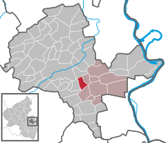 | |
 Hangen-Weisheim  Hangen-Weisheim | |
| Coordinates: 49°42′37″N 8°11′01″E / 49.71028°N 8.18361°E | |
| Country | Germany |
| State | Rhineland-Palatinate |
| District | Alzey-Worms |
| Municipal assoc. | Wonnegau |
| Government | |
| • Mayor (2019–24) | Harald Pflaume[1] |
| Area | |
• Total | 4.60 km2 (1.78 sq mi) |
| Elevation | 222 m (728 ft) |
| Population (2022-12-31)[2] | |
• Total | 437 |
| • Density | 95/km2 (250/sq mi) |
| Time zone | UTC+01:00 (CET) |
| • Summer (DST) | UTC+02:00 (CEST) |
| Postal codes | 55234 |
| Dialling codes | 06735 |
| Vehicle registration | AZ |
| Website | hangen-weisheim.de |
Hangen-Weisheim is an Ortsgemeinde – a municipality belonging to a Verbandsgemeinde, a kind of collective municipality – in the Alzey-Worms district in Rhineland-Palatinate, Germany.
Location
The municipality lies in Rhenish Hesse and belongs to the Verbandsgemeinde of Wonnegau, whose seat is in Osthofen.
History
In 773, Hangen-Weisheim had its first documentary mention.
Politics
Municipal council
The council is made up of 12 council members, who were elected by majority vote at the municipal election held on 7 June 2009, and the honorary mayor as chairman.[3]
The municipal council has formed four boards: the building board, the agriculture, winegrowing, environment and graveyard board, the accounting control board and the grape harvest board, thereby showing the municipality's prevailing character as a winegrowing centre, with boards for both winegrowing and the grape harvest.
Coat of arms
The municipality's arms might be described thus: Per fess gules the letter W surmounted by the letter H, except on the latter's cross stroke where the former surmounts it argent, and lozengy argent and azure, in base a mount of three vert.
