Amherst, Colorado
From Wikipedia, the free encyclopedia
Amherst, Colorado | |
|---|---|
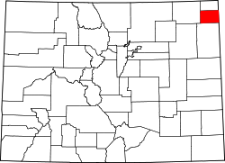
 Location within Phillips County and Colorado | |
 Amherst Location of Amherst, Colorado.  Amherst Amherst (Colorado) | |
| Coordinates: 40°40′58″N 102°09′58″W / 40.6828°N 102.1660°W[1] | |
| Country | United Statesa |
| State | Colorado |
| County | Phillips[2] |
| Founded | About 1887[3] |
| Government | |
| • Type | unincorporated community |
| • Body | Phillips County[2] |
| Area | |
• Total | 0.454 sq mi (1.176 km2) |
| • Land | 0.454 sq mi (1.176 km2) |
| • Water | 0 sq mi (0.000 km2) |
| Elevation | 3,691 ft (1,125 m) |
| Population | |
• Total | 46 |
| • Density | 100/sq mi (39/km2) |
| Time zone | UTC−07:00 (MST) |
| • Summer (DST) | UTC−06:00 (MDT) |
| ZIP Code | 80721[6] |
| Area code | 970 |
| GNIS pop ID | 182776 |
| GNIS CDP ID | 2583209 |
| FIPS code | 08-01915 |
Amherst is a census-designated place (CDP) and a post office located in Phillips County, Colorado, United States.[1] As of the United States Census 2020, the population of the Amherst CDP was 47.[5]
The town of Amherst was established about 1887.[3] The community was named after Amherst, Massachusetts, the native home of a local businessman.[7]
The Amherst Post Office opened on February 18, 1888.[8] Currently, it's ZIP Code is 80721.[6]
Phillips County was founded in 1889, and before that, Amherst was in Weld County.[9]
Geography
The Amherst CDP has an area of 291 acres (1.176 km2), all land.[4]
Demographics
| Year | Pop. | ±% |
|---|---|---|
| 2010 | 58 | — |
| 2020 | 47 | −19.0% |
| Source: United States Census Bureau | ||
The United States Census Bureau initially defined the Amherst CDP for the United States Census 2010.