Chase County, Kansas
County in Kansas, United States
From Wikipedia, the free encyclopedia
Chase County is a county located in the U.S. state of Kansas. Its county seat and most populous city is Cottonwood Falls.[2] As of the 2020 census, the county population was 2,572.[1] The county was named for Salmon Chase, a U.S. Senator from Ohio that was a Kansas statehood advocate. It is best known for the book PrairyErth: A Deep Map, a book written during, and partially about, the discussion within the county about the establishment of the Tallgrass Prairie National Preserve. It is one of several areas in Kansas that utilize prescribed burning for the maintenance of pastureland.
Courthouse.JPG)
Chase County, Kansas | |
|---|---|
| |
 Location within the U.S. state of Kansas | |
| Country |  United States United States |
| State |  Kansas Kansas |
| Founded | February 11, 1859 |
| Named after | Salmon P. Chase |
| Seat | Cottonwood Falls |
| Largest city | Cottonwood Falls |
| Area | |
• Total | 778 sq mi (2,020 km2) |
| • Land | 773 sq mi (2,000 km2) |
| • Water | 4.7 sq mi (12 km2) 0.6% |
| Population | |
• Total | 2,572 |
• Estimate (2025) | 2,572  |
| • Density | 3.3/sq mi (1.3/km2) |
| Time zone | UTC−6 (Central) |
| • Summer (DST) | UTC−5 (CDT) |
| Area code | 620 |
| Congressional district | 2nd |
| Website | chasecountyks.com |
History
Early history
For many millennia, the Great Plains of North America was inhabited by nomadic Native Americans. From the 16th century to 18th century, the Kingdom of France claimed ownership of large parts of North America. In 1762, after the French and Indian War, France secretly ceded New France to Spain, per the Treaty of Fontainebleau. In 1802, Spain returned most of the land to France, but keeping title to about 7,500 square miles.
In 1803, most of the land for modern day Kansas was acquired by the United States from France as part of the 828,000 square mile Louisiana Purchase for 2.83 cents per acre. In 1848, after the Mexican–American War, the Treaty of Guadalupe Hidalgo with Mexico brought into the United States all or part of land for ten future states, including southwest Kansas. In 1854, the Kansas Territory was organized, then in 1861 Kansas became the 34th U.S. state.
19th century
In 1806, Zebulon Pike led the Pike Expedition westward from St Louis, Missouri, of which part of their journey followed the Cottonwood River through modern Chase County.[3]
In 1859, Chase County was established within the Kansas Territory.
In 1871, the Atchison, Topeka and Santa Fe Railway extended a main line from Emporia to Newton.[4] In 1887, Atchison, Topeka and Santa Fe Railway built a branch line from Neva (3 miles west of Strong City) to Superior, Nebraska. This branch line connected Strong City, Neva, Rockland, Diamond Springs, Burdick, Lost Springs, Jacobs, Hope, Navarre, Enterprise, Abilene, Talmage, Manchester, Longford, Oak Hill, Miltonvale, Aurora, Huscher, Concordia, Kackley, Courtland, Webber, Superior. At some time, the line from Neva to Lost Springs was pulled but the right of way has not been abandoned. This branch line was originally called "Strong City and Superior line" but later the name was shortened to the "Strong City line". In 1996, the Atchison, Topeka and Santa Fe Railway merged with Burlington Northern Railroad and renamed to the current BNSF Railway.
On the south-western border with Marion County, there is a noticeable "notch." This was established after a murder took place in the area and the county government of Marion, not wishing to host the trial, permanently ceded the area (one mile wide and eighteen miles long) to Chase County. This shifted the legal jurisdiction of the case, meaning that it was Chase County's responsibility to run the trial.[5]
20th century
In 1931, Notre Dame coach Knute Rockne died in a plane crash a few miles southwest of Bazaar, in Chase County, Kansas.
In 1991, the county was the subject of the book PrairyErth: (A Deep Map). The writing of the book coincided with local debate over the establishment of the Tallgrass Prairie National Preserve, ultimately cumulating in its establishment as a joint public/private partnership with the passage of Senate bill S. 2412.
In 1996, the Tallgrass Prairie National Preserve was established in the county following Senate bill S. 2412.
Until circa February 7, 2017, the largest landowner in the county was Bill Haw (the previous CEO of National Farms Inc.). Before selling his property in the county, he possessed two ranches with a combined acreage of 14,000 acres near Bazaar. The land sold was put into a Conservation easement to limit the buildings constructed on the property in an attempt to preserve the natural scenery. It was not added to the Tallgrass Prairie National Preserve.[6]
The center of population of Kansas is located in Cottonwood Falls, Kansas, about four miles north of Strong City.
Historical markers
Historical maps
 1891 Atchison, Topeka & Santa Fe Railway route map from Grain Dealers and Shippers Gazetteer.
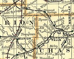 1893 Railroad Map.
 1900-1905 Atchison, Topeka & Santa Fe Railway route map of regular stops
 1914 railroad map.
 2000 Kansas population map.


Geography
According to the U.S. Census Bureau, the county has a total area of 778 square miles (2,020 km2), of which 773 square miles (2,000 km2) is land and 4.7 square miles (12 km2) (0.6%) is water.[11]
Chase County is centrally located in the eastern half of the state in the Flint Hills geologic region. It's located in the Neosho River drainage basin.[12]
Adjacent counties
- Morris County (north)
- Lyon County (east)
- Greenwood County (southeast)
- Butler County (southwest)
- Marion County (west)
National protected area
Major highways


Demographics
| Census | Pop. | Note | %± |
|---|---|---|---|
| 1860 | 1,046 | — | |
| 1870 | 1,975 | 88.8% | |
| 1880 | 6,081 | 207.9% | |
| 1890 | 8,233 | 35.4% | |
| 1900 | 8,246 | 0.2% | |
| 1910 | 7,527 | −8.7% | |
| 1920 | 7,144 | −5.1% | |
| 1930 | 6,952 | −2.7% | |
| 1940 | 6,345 | −8.7% | |
| 1950 | 4,831 | −23.9% | |
| 1960 | 3,921 | −18.8% | |
| 1970 | 3,408 | −13.1% | |
| 1980 | 3,309 | −2.9% | |
| 1990 | 3,021 | −8.7% | |
| 2000 | 3,030 | 0.3% | |
| 2010 | 2,790 | −7.9% | |
| 2020 | 2,572 | −7.8% | |
| 2025 (est.) | 2,572 | [15] | 0.0% |
| U.S. Decennial Census[16] 1790-1960[17] 1900-1990[18] 1990-2000[19] 2010-2020[1] | |||
2020 census
As of the 2020 census, the county had a population of 2,572 and a median age of 45.4 years. About 20.5% of residents were under the age of 18, 23.3% were 65 years of age or older, and there were 112.2 males for every 100 females and 112.1 males for every 100 females age 18 and over.[20]
None of the county's residents lived in an urban area, while 100.0% lived in rural areas as of the 2020 census.[21]
The racial makeup of the county was 88.3% White, 0.8% Black or African American, 0.6% American Indian and Alaska Native, 0.3% Asian, 0.1% Native Hawaiian and Pacific Islander, 5.7% from some other race, and 4.2% from two or more races. Hispanic or Latino residents of any race comprised 8.6% of the population.[22]
There were 1,056 households in the county, of which 26.5% had children under the age of 18 living with them and 21.5% had a female householder with no spouse or partner present. About 31.7% of all households were made up of individuals and 17.5% had someone living alone who was 65 years of age or older.[20]
There were 1,397 housing units, of which 24.4% were vacant. Among occupied housing units, 76.6% were owner-occupied and 23.4% were renter-occupied. The homeowner vacancy rate was 2.5% and the rental vacancy rate was 10.8%.[20]
2000 census
As of the 2000 census,[23] there were 3,030 people, 1,246 households, and 817 families residing in the county. The population density was 4 people per square mile (1.5 people/km2). There were 1,529 housing units at an average density of 2 per square mile (0.77/km2). The racial makeup of the county was 96.90% White, 1.02% Black or African American, 0.56% Native American, 0.13% Asian, 0.56% from other races, and 0.83% from two or more races. Hispanic or Latino of any race were 1.75% of the population.
There were 1,246 households, out of which 28.30% had children under the age of 18 living with them, 54.60% were married couples living together, 7.60% had a female householder with no husband present, and 34.40% were non-families. 31.10% of all households were made up of individuals, and 14.90% had someone living alone who was 65 years of age or older. The average household size was 2.34 and the average family size was 2.92.
In the county, the population was spread out, with 24.10% under the age of 18, 6.50% from 18 to 24, 26.60% from 25 to 44, 24.10% from 45 to 64, and 18.70% who were 65 years of age or older. The median age was 40 years. For every 100 females, there were 103.90 males. For every 100 females age 18 and over, there were 99.40 males.
The median income for a household in the county was $32,656, and the median income for a family was $39,848. Males had a median income of $27,402 versus $21,528 for females. The per capita income for the county was $17,422. About 4.10% of families and 8.60% of the population were below the poverty line, including 10.00% of those under age 18 and 6.30% of those age 65 or over.
Government
Presidential elections
Chase County is a Republican stronghold. The last Democrat to carry this county was Franklin D. Roosevelt in 1936.
| Year | Republican | Democratic | Third party(ies) | |||
|---|---|---|---|---|---|---|
| No. | % | No. | % | No. | % | |
| 1888 | 1,126 | 54.11% | 593 | 28.50% | 362 | 17.40% |
| 1892 | 891 | 47.37% | 0 | 0.00% | 990 | 52.63% |
| 1896 | 812 | 44.74% | 981 | 54.05% | 22 | 1.21% |
| 1900 | 1,084 | 52.49% | 956 | 46.30% | 25 | 1.21% |
| 1904 | 1,217 | 64.39% | 562 | 29.74% | 111 | 5.87% |
| 1908 | 1,021 | 53.04% | 834 | 43.32% | 70 | 3.64% |
| 1912 | 476 | 25.41% | 812 | 43.35% | 585 | 31.23% |
| 1916 | 1,356 | 44.14% | 1,584 | 51.56% | 132 | 4.30% |
| 1920 | 1,659 | 63.15% | 904 | 34.41% | 64 | 2.44% |
| 1924 | 1,822 | 62.61% | 758 | 26.05% | 330 | 11.34% |
| 1928 | 2,079 | 72.79% | 739 | 25.88% | 38 | 1.33% |
| 1932 | 1,485 | 45.96% | 1,703 | 52.71% | 43 | 1.33% |
| 1936 | 1,610 | 48.42% | 1,706 | 51.31% | 9 | 0.27% |
| 1940 | 1,871 | 57.78% | 1,344 | 41.51% | 23 | 0.71% |
| 1944 | 1,510 | 59.99% | 998 | 39.65% | 9 | 0.36% |
| 1948 | 1,432 | 58.93% | 961 | 39.55% | 37 | 1.52% |
| 1952 | 1,815 | 77.76% | 513 | 21.98% | 6 | 0.26% |
| 1956 | 1,553 | 74.45% | 529 | 25.36% | 4 | 0.19% |
| 1960 | 1,276 | 64.06% | 708 | 35.54% | 8 | 0.40% |
| 1964 | 902 | 50.31% | 886 | 49.41% | 5 | 0.28% |
| 1968 | 1,038 | 62.61% | 462 | 27.86% | 158 | 9.53% |
| 1972 | 1,184 | 76.04% | 315 | 20.23% | 58 | 3.73% |
| 1976 | 922 | 57.59% | 643 | 40.16% | 36 | 2.25% |
| 1980 | 1,073 | 66.94% | 413 | 25.76% | 117 | 7.30% |
| 1984 | 1,162 | 74.01% | 393 | 25.03% | 15 | 0.96% |
| 1988 | 884 | 60.63% | 538 | 36.90% | 36 | 2.47% |
| 1992 | 610 | 36.20% | 470 | 27.89% | 605 | 35.91% |
| 1996 | 778 | 50.19% | 496 | 32.00% | 276 | 17.81% |
| 2000 | 848 | 64.39% | 391 | 29.69% | 78 | 5.92% |
| 2004 | 1,055 | 70.29% | 418 | 27.85% | 28 | 1.87% |
| 2008 | 976 | 70.52% | 383 | 27.67% | 25 | 1.81% |
| 2012 | 875 | 68.84% | 358 | 28.17% | 38 | 2.99% |
| 2016 | 969 | 70.78% | 316 | 23.08% | 84 | 6.14% |
| 2020 | 1,123 | 75.32% | 345 | 23.14% | 23 | 1.54% |
| 2024 | 1,090 | 74.56% | 348 | 23.80% | 24 | 1.64% |
Laws
Following amendment to the Kansas Constitution in 1986, the county remained a prohibition, or "dry", county until 1988, when voters approved the sale of alcoholic liquor by the individual drink with a 30% food sales requirement.[24]
Education
Unified school districts
School districts include:[25]
- Chase County USD 284 (most of the county)
- School district office in neighboring county[25]
Communities

List of townships / incorporated cities / unincorporated communities / extinct former communities within Chase County.[26]
Cities
- Cedar Point
- Cottonwood Falls (county seat)
- Elmdale
- Matfield Green
- Strong City
Unincorporated places
Ghost towns
‡ means a community has portions in an adjacent county.
Townships
Chase County is divided into nine townships. None of the cities within the county are considered governmentally independent, and all figures for the townships include those of the cities. In the following table, the population center is the largest city (or cities) included in that township's population total, if it is of a significant size.
| Township | FIPS | Population center |
Population | Population density /km2 (/sq mi) |
Land area km2 (sq mi) | Water area km2 (sq mi) | Water % | Geographic coordinates |
|---|---|---|---|---|---|---|---|---|
| Bazaar | 04700 | 81 | 0 (1) | 293 (113) | 0 (0) | 0.17% | 38°15′55″N 96°32′3″W | |
| Cedar | 11225 | 116 | 1 (2) | 142 (55) | 0 (0) | 0.22% | 38°8′54″N 96°46′30″W | |
| Cottonwood | 15875 | 184 | 1 (2) | 209 (81) | 0 (0) | 0.23% | 38°17′23″N 96°45′44″W | |
| Diamond Creek | 17975 | 237 | 1 (2) | 373 (144) | 1 (0) | 0.24% | 38°25′31″N 96°40′35″W | |
| Falls | 22850 | Cottonwood Falls | 1,163 | 9 (23) | 131 (51) | 1 (0) | 0.42% | 38°21′55″N 96°32′27″W |
| Homestead | 32950 | 52 | 0 (1) | 141 (54) | 0 (0) | 0.27% | 38°10′56″N 96°42′14″W | |
| Matfield | 45125 | 155 | 0 (1) | 316 (122) | 1 (0) | 0.29% | 38°8′59″N 96°30′56″W | |
| Strong | 68600 | Strong City | 740 | 4 (11) | 172 (67) | 0 (0) | 0.24% | 38°24′20″N 96°32′18″W |
| Toledo | 70775 | 302 | 1 (3) | 233 (90) | 1 (0) | 0.44% | 38°24′49″N 96°23′50″W | |
| Sources: "Census 2000 U.S. Gazetteer Files". U.S. Census Bureau, Geography Division. Archived from the original on August 2, 2002. | ||||||||
In popular culture
Chase County was most prominently the focus of the book PrairyErth: A Deep Map (1991) by William Least Heat-Moon, the follow-up to his book Blue Highways.
NRHP sites
The following sites in Chase County are listed on the National Register of Historic Places:
|
|
See also
- National Register of Historic Places listings in Chase County, Kansas
- Cottonwood River and Great Flood of 1951
- Community information for Kansas

