Chimney Rock, Colorado
From Wikipedia, the free encyclopedia
Chimney Rock, Colorado | |
|---|---|
 Chimney Rock Location of Chimney Rock, Colorado.  Chimney Rock Chimney Rock (Colorado) | |
| Coordinates: 37°13′43″N 107°20′47″W / 37.2286°N 107.3464°W[1] | |
| Country | United States |
| State | Colorado |
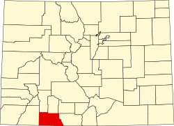
| County | Archuleta[2] |
| Government | |
| • Type | unincorporated community |
| • Body | Archuleta County[2] |
| Elevation | 6,560 ft (2,000 m) |
| Time zone | UTC−07:00 (MST) |
| • Summer (DST) | UTC−06:00 (MDT) |
| ZIP code[3] | |
| Area codes | 970/748 |
| GNIS place ID | 196439 |
Chimney Rock is an unincorporated community and former post office in Archuleta County, Colorado, United States.[1] The Chimney Rock community is located along U.S. Route 160, 3.4 miles (5.5 km) northwest of the Chimney Rock pillar in Chimney Rock National Monument.
Geography
The Chimney Rock community is located in Archuleta County at coordinates 37°13′43″N 107°20′47″W / 37.2286°N 107.3464°W and elevation 6,560 feet (1,999 m).[1] The Chimney Rock pillar is located at coordinates 37°11′41″N 107°18′03″W / 37.1946°N 107.3009°W and elevation 7,884 feet (2,403 m).[6]