Denmark Township, Emmet County, Iowa
From Wikipedia, the free encyclopedia
Denmark Township | |
|---|---|
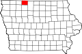
 Location in Emmet County | |
| Coordinates: 43°17′52″N 94°30′12″W / 43.29778°N 94.50333°W | |
| Country | |
| State | |
| County | Emmet |
| Area | |
• Total | 36.00 sq mi (93.24 km2) |
| • Land | 36.00 sq mi (93.24 km2) |
| • Water | 0 sq mi (0 km2) 0% |
| Elevation | 1,266 ft (386 m) |
| Population (2000) | |
• Total | 588 |
| • Density | 17/sq mi (6.4/km2) |
| Time zone | UTC-6 (CST) |
| • Summer (DST) | UTC-5 (CDT) |
| ZIP codes | 50514, 50578 |
| GNIS feature ID | 0467703 |
Denmark Township is one of twelve townships in Emmet County, Iowa, United States. As of the 2000 census, its population was 588.[1]
Denmark Township was created in 1883. It was named in honor of a group of Danish families who had arrived shortly before the establishment of the township.[2]
Geography
According to the United States Census Bureau, Denmark Township covers an area of 35.5 square miles (91.94 square kilometers).
Cities, towns, villages
Unincorporated towns
(This list is based on USGS data and may include former settlements.)
Adjacent townships
- Armstrong Grove Township (north)
- Swea Township, Kossuth County (northeast)
- Seneca Township, Kossuth County (east)
- Fenton Township, Kossuth County (southeast)
- Independence Township, Palo Alto County (south)
- Vernon Township, Palo Alto County (southwest)
- Jack Creek Township (west)
- Swan Lake Township (northwest)
Cemeteries
The township contains these three cemeteries: Ringsted Memorial, Saint Johns Lutheran and Saint Pauls.
Major highways
School districts
- Armstrong-Ringsted Community School District