Donnelly, Alaska
From Wikipedia, the free encyclopedia
Donnelly | |
|---|---|
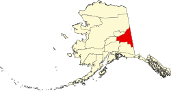
 Donnelly Location within the state of Alaska | |
| Coordinates: 63°40′25″N 145°53′0″W / 63.67361°N 145.88333°W | |
| Country | United States |
| State | Alaska |
| Census area | Southeast Fairbanks |
| Government | |
| • State senator | Mike Dunleavy (R) |
| • State rep. | George Rauscher (R) |
| Elevation | 1,785 ft (544 m) |
| Time zone | UTC-9 (Alaska (AKST)) |
| • Summer (DST) | UTC-8 (AKDT) |
| GNIS feature ID | 1401340[1] |
Donnelly is an unincorporated community in Southeast Fairbanks Census Area, Alaska, United States. Its elevation is 1,785 feet (544 m). Located along the Richardson Highway 26 miles (42 km) south of Delta Junction, it was founded around 1904 as a telegraph station between Chitina and Fairbanks.[1] Donnelly's buildings during its early years were log constructed.[2]