Jack Wade, Alaska
From Wikipedia, the free encyclopedia
Jack Wade | |
|---|---|
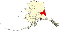
 Jack Wade Location within the state of Alaska | |
| Coordinates: 64°9′15″N 141°27′35″W / 64.15417°N 141.45972°W | |
| Country | United States |
| State | Alaska |
| Census area | Southeast Fairbanks |
| Government | |
| • State senator | Click Bishop (R) |
| • State rep. | Dave Talerico (R) |
| Elevation | 2,428 ft (740 m) |
| Time zone | UTC-9 (Alaska (AKST)) |
| • Summer (DST) | UTC-8 (AKDT) |
| GNIS feature ID | 1404039[1] |
Jack Wade is an unincorporated community in Southeast Fairbanks Census Area, Alaska, United States. Its elevation is 2,428 feet (740 m), and it is located along Wade Creek at 64°9′15″N 141°27′35″W / 64.15417°N 141.45972°W (64.1541667, -141.4597222), about 46 miles (74 km) south of Eagle[1] near the Canada–US border.[2] Founded as a mining camp around 1900, it was named for Jack Anderson and Wade Nelson, the original locators. Jack Wade received a post office in 1901, which remained until 1948.[1]