Whitestone, Alaska
From Wikipedia, the free encyclopedia
Whitestone, Alaska | |
|---|---|
 Whitestone, Alaska | |
| Coordinates: 64°09′10″N 145°54′23″W / 64.15278°N 145.90639°W | |
| Country | United States |
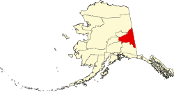
| State | Alaska |
| Census Area | Southeast Fairbanks |
| Government | |
| • State senator | Click Bishop (R) |
| • State rep. | Mike Cronk (R) |
| Area | |
• Total | 7.04 sq mi (18.24 km2) |
| • Land | 7.04 sq mi (18.24 km2) |
| • Water | 0 sq mi (0.00 km2) |
| Elevation | 984 ft (300 m) |
| Population (2020) | |
• Total | 71 |
| • Density | 10.1/sq mi (3.89/km2) |
| Time zone | UTC-9 (Alaska (AKST)) |
| • Summer (DST) | UTC-8 (AKDT) |
| ZIP code | 99737[2] |
| Area code | 907 |
| GNIS feature ID | 2582719[3] |
Whitestone is an unincorporated community and census-designated place in Southeast Fairbanks Census Area, Alaska, United States. Its population was 71 as of the 2020 census. This is not to be confused with Whitestone Logging Camp CDP in the Alaskan panhandle.