Dorstadt
From Wikipedia, the free encyclopedia
Dorstadt | |
|---|---|
 Manor house | |
 Coat of arms | |
Location of Dorstadt
within Wolfenbüttel district 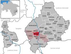 | |
 Location of Dorstadt | |
 Dorstadt  Dorstadt | |
| Coordinates: 52°06′N 10°34′E / 52.100°N 10.567°E | |
| Country | Germany |
| State | Lower Saxony |
| District | Wolfenbüttel |
| Municipal assoc. | Oderwald |
| Government | |
| • Mayor | Bruno Polzin (SPD) |
| Area | |
• Total | 10.36 km2 (4.00 sq mi) |
| Elevation | 80 m (260 ft) |
| Population (2024-12-31)[1] | |
• Total | 708 |
| • Density | 68.3/km2 (177/sq mi) |
| Time zone | UTC+01:00 (CET) |
| • Summer (DST) | UTC+02:00 (CEST) |
| Postal codes | 38312 |
| Dialling codes | 05337 |
| Vehicle registration | WF |
Dorstadt is a municipality in the district of Wolfenbüttel, in Lower Saxony, Germany. It is part of the Samtgemeinde ("collective municipality") Oderwald.
Dorstadt is located in the northern foothills of the Harz mountain range. The municipal area stretches from the eastern slopes of the Oderwald hills down to the Oker river, about halfway between Wolfenbüttel and Schladen. Neighbouring municipalities are Ohrum in the north and Heiningen in the south, as well as Börßum east of the Oker.

