Kneitlingen
From Wikipedia, the free encyclopedia
Kneitlingen | |
|---|---|
 The parish church in Kneitlingen | |
Location of Kneitlingen within Wolfenbüttel district 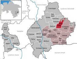 | |
 Kneitlingen  Kneitlingen | |
| Coordinates: 52°11′N 10°46′E / 52.183°N 10.767°E | |
| Country | Germany |
| State | Lower Saxony |
| District | Wolfenbüttel |
| Municipal assoc. | Elm-Asse |
| Subdivisions | 4 Ortsteile |
| Government | |
| • Mayor | Johannes Feigel (CDU) |
| Area | |
• Total | 17.58 km2 (6.79 sq mi) |
| Elevation | 223 m (732 ft) |
| Population (2022-12-31)[1] | |
• Total | 781 |
| • Density | 44/km2 (120/sq mi) |
| Time zone | UTC+01:00 (CET) |
| • Summer (DST) | UTC+02:00 (CEST) |
| Postal codes | 38170 |
| Dialling codes | 05332 |
| Vehicle registration | WF |
Kneitlingen is a municipality in the Wolfenbüttel district in the German state of Lower Saxony. It is part of the Samtgemeinde Elm-Asse. The most recent German census counted a population of just 853 people.


Kneitlingen is situated in Brunswick Land between the Elm and Asse hill ranges. The municipality consists of the following four villages:
- Ampleben
- Bansleben
- Eilum
- Kneitlingen
