Estrella, Colorado
From Wikipedia, the free encyclopedia
Estrella, Colorado | |
|---|---|
 Looking northwest on Estrella Road in Estrella, April 2018. | |
  Estrella Location of Estrella, Colorado.  Estrella Estrella (Colorado) | |
| Coordinates: 37°21′58″N 105°55′28″W / 37.3661°N 105.9245°W[1] | |
| Country | United States |
| State | Colorado |
| County | Alamosa[2] |
| Government | |
| • Type | unincorporated community |
| • Body | Alamosa County[2] |
| Elevation | 7,569 ft (2,307 m) |
| Time zone | UTC−07:00 (MST) |
| • Summer (DST) | UTC−06:00 (MDT) |
| ZIP code[3] | Alamosa 81101 |
| Area code | 719 |
| GNIS place ID | 192916 |
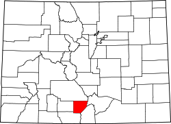
Estrella is an unincorporated community in southern Alamosa County, Colorado, United States.[1] The community is a part of the Alamosa, CO Micropolitan Statistical Area.
Estrella is a name derived from Spanish meaning "star".[4] The unincorporated community has never had its own post office.[5] The Alamosa, Colorado, post office (ZIP code 81101) serves the area.[3]
Geography
Estrella is located in southern Alamosa County at coordinates 37°21′58″N 105°55′28″W / 37.3661°N 105.9245°W and elevation 7,569 feet (2,307 m).[1]