Ganchenpo
From Wikipedia, the free encyclopedia
| Ganchenpo | |
|---|---|
| Fluted Peak | |
 West aspect | |
| Highest point | |
| Elevation | 6,378 m (20,925 ft)[1][2] |
| Prominence | 1,018 m (3,340 ft)[1] |
| Isolation | 6.33 km (3.93 mi)[1] |
| Coordinates | 28°10′08″N 85°40′52″E / 28.16889°N 85.68111°E[2] |
| Geography | |
 Ganchenpo Location in Nepal | |
 | |
| Interactive map of Ganchenpo | |
| Location | Langtang |
| Country | Nepal |
| Province | Bagmati |
| District | Rasuwa |
| Protected area | Langtang National Park[3] |
| Parent range | Himalaya |
| Climbing | |
| First ascent | 1971 |
Ganchenpo is a mountain in Nepal.
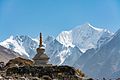
Ganchenpo, also known as Fluted Peak,[2] is a 6,378-metre (20,925-foot) glaciated summit in the Nepali Himalaya. It is situated 55 kilometres (34 mi) northeast of Kathmandu above the Langtang Valley of Langtang National Park. Precipitation runoff from the mountain's slopes drains to the Trishuli River via Lānṭān Kholā. Topographic relief is significant as the summit rises 2,380 metres (7,808 ft) above the Langtang Valley in four kilometres (2.5 mi). The first ascent of the summit was made in 1971 by Terry Bech and Cheri Bech.[2] Gangchempo, Gangchenpo, and Ganchempo are variant spellings.[2]
Climate
Based on the Köppen climate classification, Ganchenpo is located in a tundra climate zone with cold, snowy winters, and cool summers.[4] Weather systems coming off the Bay of Bengal are forced upwards by the Himalaya mountains (orographic lift), causing heavy precipitation in the form of rainfall and snowfall. Mid-June through early-August is the monsoon season. The months of April, May, September, and October offer the most favorable weather for viewing or climbing this peak.[5]
Gallery

 South aspect
 West aspect
 West aspect
 West aspect
 Ganchenpo centered


.jpg)


