Laura, Illinois
From Wikipedia, the free encyclopedia
Laura, Illinois | |
|---|---|
 Laura, Illinois  Laura, Illinois | |
| Coordinates: 40°55′17″N 89°55′35″W / 40.92139°N 89.92639°W | |
| Country | United States |
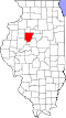
| State | Illinois |
| County | Peoria |
| Elevation | 728 ft (222 m) |
| Time zone | UTC-6 (Central (CST)) |
| • Summer (DST) | UTC-5 (CDT) |
| ZIP code | 61451 |
| Area code | 309 |
| GNIS feature ID | 411849[1] |
Laura is an unincorporated community in Peoria County, Illinois, United States. Laura is located along a railroad line, 5 miles (8.0 km) east of Williamsfield. Laura has a post office with ZIP code 61451.[2]