List of mountain peaks of Utah
Mountain peaks of Utah
From Wikipedia, the free encyclopedia
This article comprises three sortable tables of major mountain peaks of the U.S. State of Utah.

The summit of a mountain or hill may be measured in three principal ways:
- The topographic elevation of a summit measures the height of the summit above sea level.
- The topographic prominence of a summit is a measure of how high the summit rises above its surroundings.
- The topographic isolation of a summit measures how far the summit lies from its nearest point of equal elevation.
Utah contains a diverse range of mountain systems, including the high-elevation Uinta Mountains, which contain the only peaks in the state exceeding 13,000 feet in elevation. According to the Utah Geological Survey, Utah has nearly two dozen summits above 13,000 feet, all located in the Uinta Mountains.[1]
For regional peak lists in the United States, a topographic prominence[2] threshold of approximately 300 feet is commonly used to distinguish significant summits from minor subpeaks.[3]
Highest summits
The following table lists the highest summits of Utah with at least 300 feet of topographic prominence.
| Rank | Mountain peak | Mountain range | Elevation | Prominence | Isolation | Location |
|---|---|---|---|---|---|---|
| 1 | Kings Peak[4][5][a] | Uinta Mountains | 13,529 ft 4123.6 m | 6,349 ft 1935 m | 166.6 mi 268 km |
40.7764°N 110.3730°W |
| 2 | South Kings Peak[6][7] | Uinta Mountains | 13,517 ft 4119.9 m | 352 ft 107 m | 0.8 mi 1.29 km |
40.7659°N 110.3779°W |
| 3 | Gilbert Peak[8][9] | Uinta Mountains | 13,447 ft 4098.6 m | 1,559 ft 475 m | 3.6 mi 5.79 km |
40.8235°N 110.3400°W |
| 4 | Mount Emmons[10][11] | Uinta Mountains | 13,445 ft 4098 m | 913 ft 278 m | 5.4 mi 8.69 km |
40.7118°N 110.3038°W |
| 5 | Painter Peak[12] | Uinta Mountains | 13,389 ft 4081 m | 317 ft 97 m | 1.3 mi 2.09 km |
40.7531°N 110.3589°W |
| 6 | Roberts Peak[13] | Uinta Mountains | 13,297 ft 4052.9 m | 560 ft 171 m | 1.6 mi 2.57 km |
40.7356°N 110.3392°W |
| 7 | Henrys Fork Peak[14] | Uinta Mountains | 13,273 ft 4045.6 m | 553 ft 169 m | 1.1 mi 1.77 km |
40.7879°N 110.3898°W |
| 8 | Gunsight Peak[15][16] | Uinta Mountains | 13,271 ft 4045 m | 637 ft 194 m | 1.4 mi 2.25 km |
40.8034°N 110.3528°W |
| 9 | Trail Rider Peak[17] | Uinta Mountains | 13,255 ft 4040 m | 357 ft 109 m | 0.7 mi 1.13 km |
40.7422°N 110.3526°W |
| 10 | Mount Lovenia[18][19] | Uinta Mountains | 13,224 ft 4030.6 m | 1,477 ft 450 m | 11.6 mi 18.67 km |
40.7568°N 110.6071°W |
| 11 | Tokewanna Peak[20][21] | Uinta Mountains | 13,169 ft 4013.9 m | 1,291 ft 393 m | 3.8 mi 6.12 km |
40.8100°N 110.6237°W |
| 12 | Wasatch Peak[22] | Uinta Mountains | 13,159 ft 4011 m | 862 ft 263 m | 1.8 mi 2.9 km |
40.7833°N 110.6238°W |
| 13 | Mount Powell[23] | Uinta Mountains | 13,156 ft 4009.9 m | 813 ft 248 m | 0.2 mi 0.32 km |
40.7953°N 110.4249°W |
| 14 | Dome Peak[24] | Uinta Mountains | 13,100 ft 3993 m | 644 ft 196 m | 0.9 mi 1.45 km |
40.7927°N 110.3667°W |
| 15 | Pinnacle Peak[25][26] | Uinta Mountains | 13,090 ft 3989.8 m | 479 ft 146 m | 0.8 mi 1.29 km |
40.7225°N 110.3178°W |
| 16 | Wilson Peak[27][28] | Uinta Mountains | 13,058 ft 3980 m | 1,305 ft 398 m | 2.2 mi 3.54 km |
40.7759°N 110.4617°W |
| 17 | Quandary Peak[29] | Uinta Mountains | 13,037 ft 3973.6 m | 821 ft 250 m | 1.2 mi 1.93 km |
40.7627°N 110.5832°W |
| 18 | Squaw Benchmark[30] | Uinta Mountains | 12,995 ft 3960.8 m | 819 ft 250 m | 1.6 mi 2.57 km |
40.7858°N 110.4903°W |
| 19 | Porcupine Mountain[31][32] | Uinta Mountains | 12,890 ft 3929 m | 662 ft 202 m | 0.9 mi 1.45 km |
40.7616°N 110.4734°W |
| 20 | Central Blacks Fork Peak[33] | Uinta Mountains | 12,867 ft 3922 m | 1,060 ft 323 m | 2.1 mi 3.38 km |
40.7798°N 110.5491°W |
| 21 | Kweeyahgut Peak[34][35] | Uinta Mountains | 12,860 ft 3919.7 m | 982 ft 299 m | 4.2 mi 6.76 km |
40.7004°N 110.6433°W |
| 22 | South Red Castle Peak[36] | Uinta Mountains | 12,828 ft 3910 m | 500 ft 152 m | 1 mi 1.61 km |
40.7906°N 110.4605°W |
| 23 | Moose Peak[37] | Uinta Mountains | 12,799 ft 3901 m | 489 ft 149 m | 2 mi 3.22 km |
40.8173°N 110.5007°W |
| 24 | East Wilson Peak[38] | Uinta Mountains | 12,775 ft 3893.8 m | 431 ft 131 m | 0.6 mi 0.97 km |
40.7702°N 110.4514°W |
| 25 | South Blacks Fork Peak[39] | Uinta Mountains | 12,772 ft 3893 m | 350 ft 107 m | 0.5 mi 0.8 km |
40.7737°N 110.5470°W |
| 26 | Northwest Blacks Fork Peak[40] | Uinta Mountains | 12,751 ft 3886.5 m | 317 ft 97 m | 0.7 mi 1.13 km |
40.7967°N 110.5578°W |
| 27 | South Burro Peak[41][42] | Uinta Mountains | 12,733 ft 3881 m | 798 ft 243 m | 7.1 mi 11.43 km |
40.8319°N 110.1827°W |
| 28 | South Porcupine Mountain[43] | Uinta Mountains | 12,730 ft 3880 m | 398 ft 121 m | 0.7 mi 1.13 km |
40.7535°N 110.4828°W |
| 29 | Mount Peale[44][45][b] | La Sal Mountains | 12,726 ft 3879 m | 6,167 ft 1880 m | 72.8 mi 117.2 km |
38.4385°N 109.2292°W |
| 30 | LaMotte Peak[46][47] | Uinta Mountains | 12,726 ft 3879 m | 1,149 ft 350 m | 6 mi 9.66 km |
40.7737°N 110.7520°W |
| 31 | Ostler Peak[48][49] | Uinta Mountains | 12,725 ft 3878.5 m | 1,175 ft 358 m | 2.1 mi 3.38 km |
40.7466°N 110.7689°W |
| 32 | Explorer Peak[50][51] | Uinta Mountains | 12,713 ft 3875 m | 709 ft 216 m | 1.2 mi 1.93 km |
40.7183°N 110.6439°W |
| 33 | Yard Peak[52][53] | Uinta Mountains | 12,710 ft 3874 m | 1,105 ft 337 m | 2.5 mi 4.02 km |
40.7527°N 110.7134°W |
| 34 | Stone Benchmark[54] | Uinta Mountains | 12,710 ft 3874 m | 644 ft 196 m | 1.8 mi 2.9 km |
40.7336°N 110.5056°W |
| 35 | North Timothy Peak[55] | Uinta Mountains | 12,696 ft 3869.7 m | 407 ft 124 m | 1 mi 1.61 km |
40.7281°N 110.3736°W |
| 36 | Red Castle[56][57] | Uinta Mountains | 12,676 ft 3863.6 m | 460 ft 140 m | 0.5 mi 0.8 km |
40.7987°N 110.4658°W |
| 37 | East Burnt Fork Peak[58] | Uinta Mountains | 12,673 ft 3862.7 m | 1,369 ft 417 m | 4.1 mi 6.6 km |
40.8109°N 110.1090°W |
| 38 | South Timothy Peak[59] | Uinta Mountains | 12,654 ft 3856.9 m | 464 ft 141 m | 0.9 mi 1.45 km |
40.7156°N 110.3766°W |
| 39 | Mount Mellenthin[60][61] | La Sal Mountains | 12,651 ft 3856 m | 689 ft 210 m | 1.7 mi 2.74 km |
38.4633°N 109.2339°W |
| 40 | North Allsop Peak[62] | Uinta Mountains | 12,635 ft 3851 m | 981 ft 299 m | 2.1 mi 3.38 km |
40.7733°N 110.6828°W |
| 41 | Dead Horse Peak[63] | Uinta Mountains | 12,631 ft 3850 m | 743 ft 226 m | 1.3 mi 2.09 km |
40.7433°N 110.6927°W |
| 42 | Cleveland Peak[64][65] | Uinta Mountains | 12,595 ft 3838.9 m | 385 ft 117 m | 0.9 mi 1.45 km |
40.6875°N 110.6297°W |
| 43 | Mount Beulah[66][67] | Uinta Mountains | 12,561 ft 3828.5 m | 728 ft 222 m | 1.4 mi 2.25 km |
40.7940°N 110.6820°W |
| 44 | Meadow Peak[68] | Uinta Mountains | 12,551 ft 3825.5 m | 551 ft 168 m | 2 mi 3.22 km |
40.7493°N 110.6471°W |
| 45 | Spread Eagle Peak[69][70] | Uinta Mountains | 12,546 ft 3824 m | 838 ft 255 m | 1.1 mi 1.77 km |
40.7297°N 110.7836°W |
| 46 | Oweep Peak[71] | Uinta Mountains | 12,536 ft 3821 m | 469 ft 143 m | 1.2 mi 1.93 km |
40.7640°N 110.5156°W |
| 47 | Cleve Peak[72] | Uinta Mountains | 12,526 ft 3817.9 m | 1,144 ft 349 m | 3.2 mi 5.15 km |
40.7653°N 110.1360°W |
| 48 | Val Benchmark Peak[73] | Uinta Mountains | 12,512 ft 3813.6 m | 784 ft 239 m | 2.7 mi 4.35 km |
40.7606°N 110.2887°W |
| 49 | South Yard Peak[74] | Uinta Mountains | 12,503 ft 3810.9 m | 420 ft 128 m | 0.5 mi 0.8 km |
40.7455°N 110.7214°W |
| 50 | Mount Tukuhnikivatz[75][76] | La Sal Mountains | 12,484 ft 3805 m | 756 ft 230 m | 1.5 mi 2.41 km |
38.4395°N 109.2598°W |
Most prominent summits
Of the most prominent summits of Utah, eight peaks are ultra-prominent summits with more than 1500 meters (4921 feet) of topographic prominence and 33 peaks exceed 1000 meters (3281 feet) of topographic prominence.
Most isolated major summits
Of the most isolated major summits of Utah, Kings Peak exceeds 200 kilometers (124.3 miles) of topographic isolation and four peaks exceed 100 kilometers (62.14 miles) of topographic isolation.
Gallery


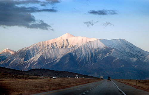 Mount Nebo is the highest summit of the Wasatch Range.
 Mount Timpanogos (back/east side)


See also

.svg)


- List of mountain peaks of North America
- List of mountain peaks of Greenland
- List of mountain peaks of Canada
- List of mountain peaks of the Rocky Mountains
- List of mountain peaks of the United States
- List of mountain peaks of Alaska
- List of mountain peaks of Arizona
- List of mountain peaks of California
- List of mountain peaks of Colorado
- List of mountain peaks of Hawaiʻi
- List of mountain peaks of Idaho
- List of mountain peaks of Montana
- List of mountain peaks of Nevada
- List of mountain peaks of New Mexico
- List of mountain peaks of Oregon
- List of mountain peaks of Utah
- List of mountain peaks of Washington (state)
- List of mountain peaks of Wyoming
- List of mountain peaks of México
- List of mountain peaks of Central America
- List of mountain peaks of the Caribbean
- Utah
- Physical geography
Notes
- The summit of Kings Peak is the highest point of the Uinta Mountains.
- The summit of Mount Peale is the highest point of the La Sal Mountains.
- The elevation of Kings Peak includes an adjustment of +1.807 m (5.93 ft) from NGVD 29 to NAVD 88.
- The summit of Mount Ellen Peak is the highest point of the Henry Mountains.
- The elevation of Mount Ellen Peak includes an adjustment of +1.486 m (4.88 ft) from NGVD 29 to NAVD 88.
- The summit of Deseret Peak is the highest point of the Stansbury Mountains.
- The summit of Mount Nebo is the highest point of the Wasatch Range.
- The elevation of Mount Nebo includes an adjustment of +1.395 m (4.58 ft) from NGVD 29 to NAVD 88.
- The summit of Flat Top Mountain is the highest point of the Oquirrh Mountains.
- The elevation of Flat Top Mountain includes an adjustment of +1.329 m (4.36 ft) from NGVD 29 to NAVD 88.
- The summit of Mount Timpanogos is the highest point of the central Wasatch Range.
- The summit of Ibapah Peak is the highest point of the Deep Creek Range.
- The elevation of Ibapah Peak includes an adjustment of +1.517 m (4.98 ft) from NGVD 29 to NAVD 88.
- The summit of Delano Peak is the highest point of the Tushar Mountains.
- The summit of Abajo Peak is the highest point of the Abajo Mountains.
- The summit of Swasey Peak is the highest point of the House Range.
- The summit elevation of Swasey Peak includes a vertical offset of +0.61 m (2 ft) from the station benchmark.
- The summit of Signal Peak is the highest point of the Pine Valley Mountains.
- The elevation of Signal Peak includes an adjustment of +1.249 m (4.1 ft) from NGVD 29 to NAVD 88.
- The summit of Fish Lake Hightop is the highest point of the Fish Lake Plateau.
- The summit of Monroe Peak is the highest point of the Sevier Plateau.
- The summit of Frisco Peak is the highest point of the San Francisco Mountains.
- The summit of Brian Head is the highest point of the Markagunt Plateau.
- The elevation of Brian Head includes an adjustment of +1.556 m (5.1 ft) from NGVD 29 to NAVD 88.
- The summit of Bull Mountain is the highest point of the Raft River Mountains.
- The elevation of Bull Mountain includes an adjustment of +1.343 m (4.41 ft) from NGVD 29 to NAVD 88.
- The summit of Fool Creek Peak is the highest point of the Canyon Mountains.
- The summit of Salt Benchmark is the highest point of the San Pitch Mountains.
- The elevation of Twin Peaks includes an adjustment of +1.463 m (4.8 ft) from NGVD 29 to NAVD 88.
- The summit of Indian Peak is the highest point of the Indian Peak Range.
- The summit of West Mountain Peak is the highest point of the Beaver Dam Mountains.
- The summit of George H. Hansen Peak is the highest point of the Fish Springs Range.
- The summit of Box Elder Peak is the highest point of the Wellsvillle Mountains.
- The elevation of Provo Peak includes an adjustment of +1.31 m (4.3 ft) from NGVD 29 to NAVD 88.
- The summit elevation of Notch Peak includes a vertical offset of +0.102 m (0.3 ft) from the station benchmark.
- The summit of South Tent Mountain is the highest point of the Wasatch Plateau.
- The elevation of Mount Hillers includes an adjustment of +1.364 m (4.48 ft) from NGVD 29 to NAVD 88.
- The summit of Willard Peak is the highest point of the northern Wasatch Range.
- The summit of Naomi Peak is the highest point of the Bear River Mountains.
- The summit of Wah Wah Mountain is the highest point of the Wah Wah Mountains.
- The summit of Granite Peak is the highest point of the Mineral Mountains.
- The summit elevation of Granite Peak includes a vertical offset of +0.61 m (2 ft) from the station benchmark.
- The summit of Mine Camp Peak is the highest point of the Pavant Range.
- The elevation of Bluebell Knoll includes an adjustment of +1.708 m (5.6 ft) from NGVD 29 to NAVD 88.
- The summit of Strawberry Peak is the highest point of the Roan Cliffs.
- The summit of Indian Peak is the highest point of the Indian Peak Range.
- The elevation of Shay Mountain includes an adjustment of +1.249 m (4.1 ft) from NGVD 29 to NAVD 88.


